And the severe weather pattern is just perfectly boring for the Central/Southern Plains. A large dome of high pressure is sitting over the middle of the country, cranking the oven up and keeping severe weather chances to a minimum for now.
And did I mention it was hot?
Thanks for reading Tornado Titans! Subscribe for free to receive new posts and support my work.
This ridge is no joke. Ensembles have it parked over Oklahoma/Kansas this weekend.
With time the ridge will likely weaken some into next week taking an edge off of the temperatures (and by edge we mean 105 to 95). But the quieter pattern will probably be persistent at least to next weekend.
Models differ on how they handle the pattern evolution into next weekend, with the Euro building a stronger Four-Corners High over the Southwest. This would probably shunt the jet stream pattern well north.
Something to watch in the extended would be for glancing shots of modest flow (20kt or so at 500mb) working over the High Plains. This could bring a localized severe weather threat underneath N’ly upper flow. But…yeah. Not counting on it.
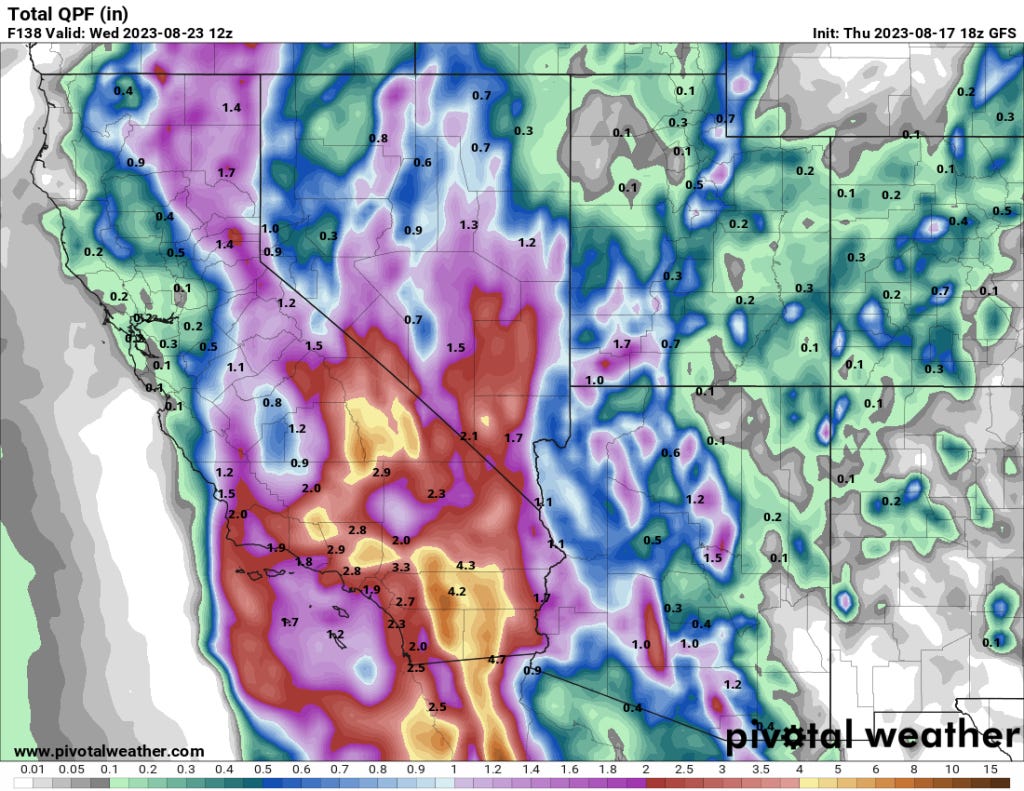
In fact, the biggest weather story of the week for the extended region is the rainfall/flash flooding threat from Hurricane Hillary in the Southwest. Some areas could pick up a year or more worth of rain in 24-48 hours!
The Bottom Line
I’m not seeing many signs of an early surging fall season just yet, we do sometimes get robust supercell threats on the Central/Southern Plains in September. But for now, I think summer will remain the season we are stuck with. Maybe the ridge evolution is as such we can get robust cool air intrusions in the NW’ly flow by the start of September. Maybe.
Stay cool my friends.
Thank you for reading Tornado Titans. This post is public so feel free to share it.


That GFS at 240 hours (as of last night) has some mischief in the GoM. Can that help erode or weaken or bust the silly strong H pressure cell?