


The Ridge Dominates
There aren't many signs of it flattening out or weakening for awhile at this point...

In our last post, we talked about how there were some signs the ridge parked over the central U.S. might flatten out and shift west some by mid-July bringing reasonable severe weather chances to the Plains again — but models are converging on a scenario that really isn’t that.

Overall the ridge looks to remain in place across the central U.S. with the typical sinking air and extremely hot temperatures the dominant weather feature. While this storm chaser is wanting to chase some more supercells this summer, I’m not quite ready to make a 14 hour drive north to do so!

The place to look for severe weather activity in this pattern would be the far northern Plains into Canada primarily. There are occasional shots of jet stream energy across the Midwest and New England as energy rides up and over the ridge. Additionally, widespread summer storms in the southeast will bring at least some damaging winds potential most every day. In short: it is summer in every traditional sense!
DROUGHT!
I really wish I had better news! The drought situation across the country really isn’t seeing much improvement in most areas except the Southwest thanks to the monsoon season.

Widespread drought across the west is both a sign of a quiet severe weather pattern and also a contributor to a quiet severe weather pattern. For the Plains, especially the High Plains, to not be in drought — there usually needs to be an active Spring severe weather season. As drought expands and builds over the west, it can also create stronger capping inversions over the Plains — which can tend to reinforce the quiet severe weather patterns by knocking down setups that might have otherwise produced storms.
Droughts do eventually break thanks to large-scale pattern changes — but the bigger the drought the more drastic the pattern change to break it has to be. Currently, we’d need a lot of global conditions to flip from their current state to get most of the west out of drought at this point.
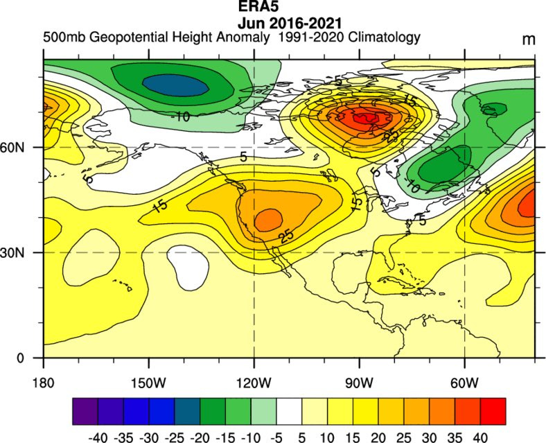
The New Normal?
There has been discussion on social media about the quicker building ridge in June across the western U.S. and the subsequent fall in tornado activity over the country. This is a long-term trend that could be influenced by warmer overall global temperatures, which effectively acts to shorten the span of peak tornado season in the country.
We’ll have a video on all of this on our YouTube channel, which is about to celebrate a grand re-launch later this month! Be sure to subscribe and allow notifications so you know exactly when we post new videos!
I wish May was a 3 month thing.