

What It's Like to Chase a Hurricane in Your Hometown
Weather hits different when it hits local.
This guest post is by Titan Jennifer Mitchell, who chases hurricanes AND tornadoes. You can find more of Jennifer’s adventures on her Instagram.
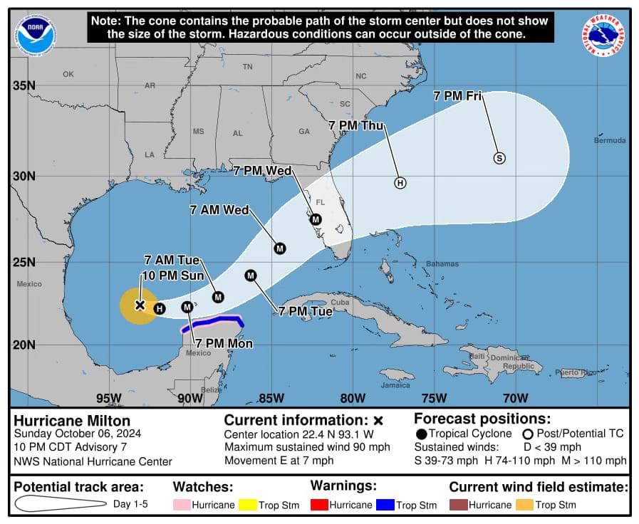
On October 7, 2024, the National Hurricane Center (NHC) showed the unthinkable that had been building up for several days - the forecast was for a Major Hurricane to come off the Yucatan peninsula and into the Gulf, making landfall a couple of days later very close to my hometown of Sarasota, FL. This would be the third Hurricane along the west coast of Florida since August.
At this point, I started to consider how to prep my house first. Thankfully, I had the plywood already cut, so it was just a matter of cleaning up my yard, getting a few supplies just in case, and making sure flashlights, fans, and chargers were all charged up.
Luckily, I am not in a flood or evacuation zone, so I generally did not have to worry about sandbags or anything like that. Once I knew my home was in good order and I had a plan for my children (who are young adults), I was ready to make my chase plan.
I am a native Floridian, and Hurricane Milton was the first hurricane that I chased in my backyard- literally! On October 8th, I started the day by filming hurricane preparations around Sarasota. We were all experts by now. Even though we had not gotten a direct hit from Debby or Helene, the entire central Gulf Coast of Florida received a lot of damage.
I shared footage on Instagram from Hurricanes Debby and Helene, showing beach hotels full of sand, dunes gone, homes and businesses that had to be gutted because of the extent of damage from flooding and storm surge. It became tricky to remember which hurricane caused what damage. That night, I charged and packed my cameras and other equipment, and prepared my “go box” and a small cooler. I figured I would most likely be out for about twenty-four hours at the most.
I am a teacher, currently a college professor of Education. My approach to Social Media during hurricane chases is to be real without panicking people. I like to educate people about what to expect and when. I have found so much hype leading up to hurricanes that it is disheartening. I share the NHC forecasts and explain them. I share my thoughts and explain why I feel that way, including any misconceptions.
By 6:30 AM on October 9, Sarasota and the rest of the central Gulf Coast of Florida were feeling the effects of the initial armbands of Milton, which brought a lot of rain on and off. Milton was now forecast to be a Major Category 5 at landfall, and it looked like Sarasota could be the prime target. It was predicted to move faster than the other two, with storm surge being the major hazard.
Each storm is so different. Debby sat along the coast for days. Helene moved onto shore and swept north across the country, pulling an unprecedented amount of rain through Appalachia.
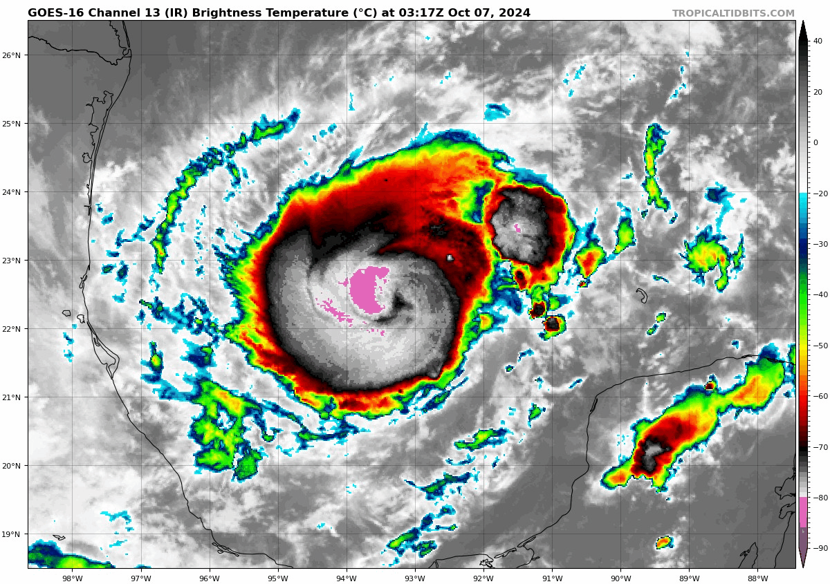
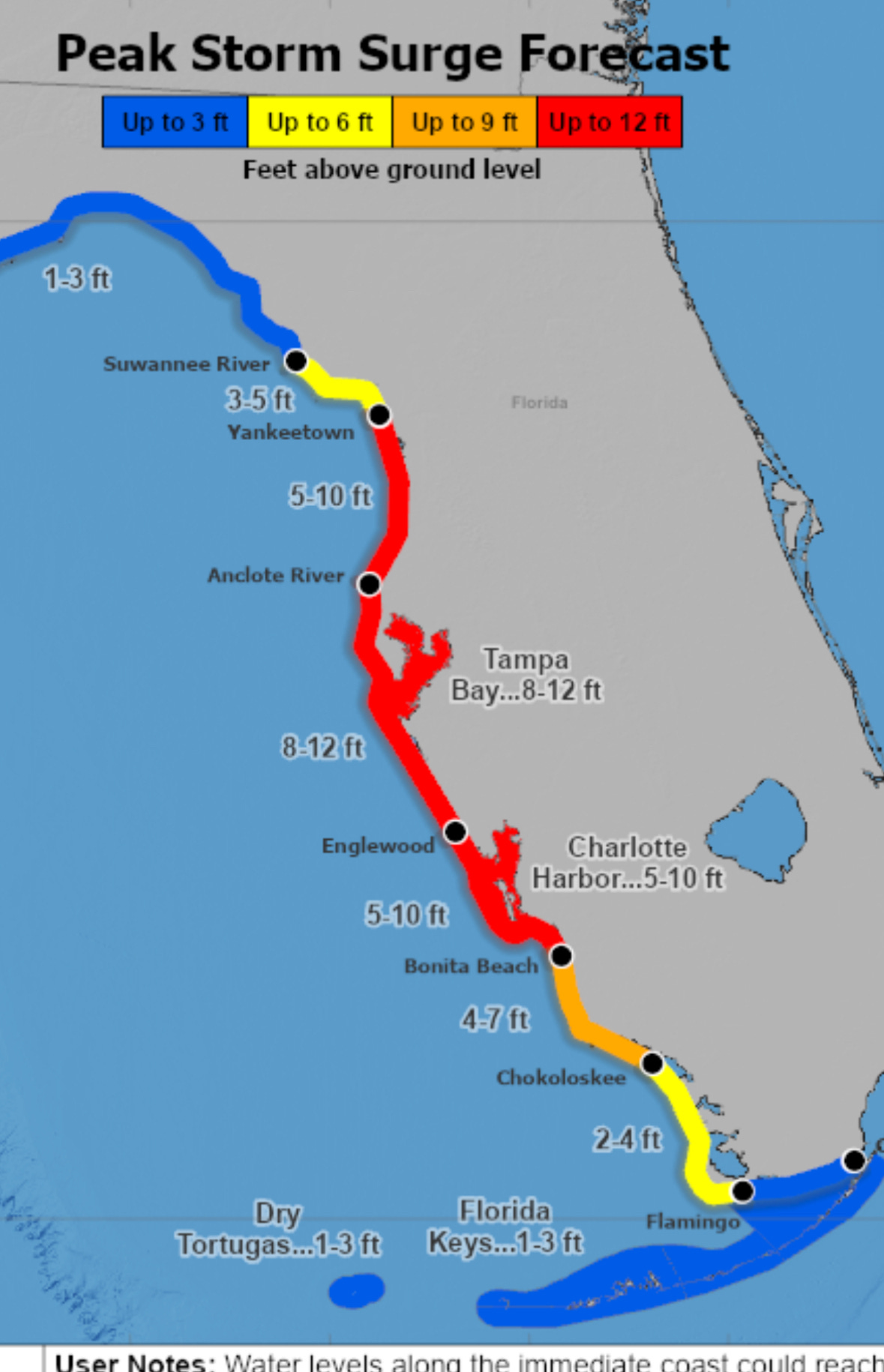
On October 9, the NHC forecasted storm surge of up to 15 feet for the central Gulf Coast of Florida. The storm was forecast to move quickly across the state and bring a storm surge of 2-4 feet to the East Coast of Florida as it exited the state. At this point, we started looking closely at Satellite images and the NHC forecast cone to better pinpoint where landfall would be.
Milton spawned several “plains-like” wedge tornadoes early the morning of October 9th. These are not normal for Florida. Tornado records for our state were broken, including the longest tornado track for southwest Florida- an F1 spanning 70 miles. At 1:00 PM, there were over seven tornado warnings in our area. That day, there were a total of 45 tornado reports, including one F3.
By 5:30 PM, we were receiving “Shelter in Place” warnings as the outer armbands tightened, bringing a lot of steady rain and flooding the roads across the Sarasota/Bradenton area. At this point, my chase partner and I decided to make parking garages around the city our refuges. They generally provide shelter from rain, winds, and flooding, are sturdy structures, and give us great views of the city.
During breaks in the rain, we ventured to the top of the garage we were in to get a better view of the rainband structure. At one point, we drove out to Siesta Key, a barrier island that would eventually become “ground zero” for Milton’s landfall. For about twenty minutes, we parked on a drawbridge as darkness fell close to 7:00 PM.
We watched power flashes around Sarasota Bay as the wind rocked my chase partner’s truck. At this point, we made the decision it was time to return to our refuge in one of the parking garages. As the inner eyewall bands came in there were points when even standing in the parking structure became impossible between the wind and heavy rains coming in. My ears always begin to pop at this point as the pressure shifts with the eyewall getting closer. We continued to see power flashes around the city, and thankfully, the power stayed on where we were. It became a surreal experience watching “my hometown” deteriorate below me.
Then, close to 8:30 PM, the eye of Category 3 Hurricane Milton made landfall, the 5th hurricane to make landfall in the US in 2024, on Siesta Key, six miles from where we were. Sustained winds were 120 MPH and pressure of 954MB.
After hours of endless rain and loud, whipping wind, there was an eerie silence as the eye came over. The winds and rain had basically stopped, and we went back to the top of the garage. I did a livestream then and shared what we had been through, what was happening now, and what to expect next. I noticed, with pride, that several of my college students were watching the stream from various cities in Florida.
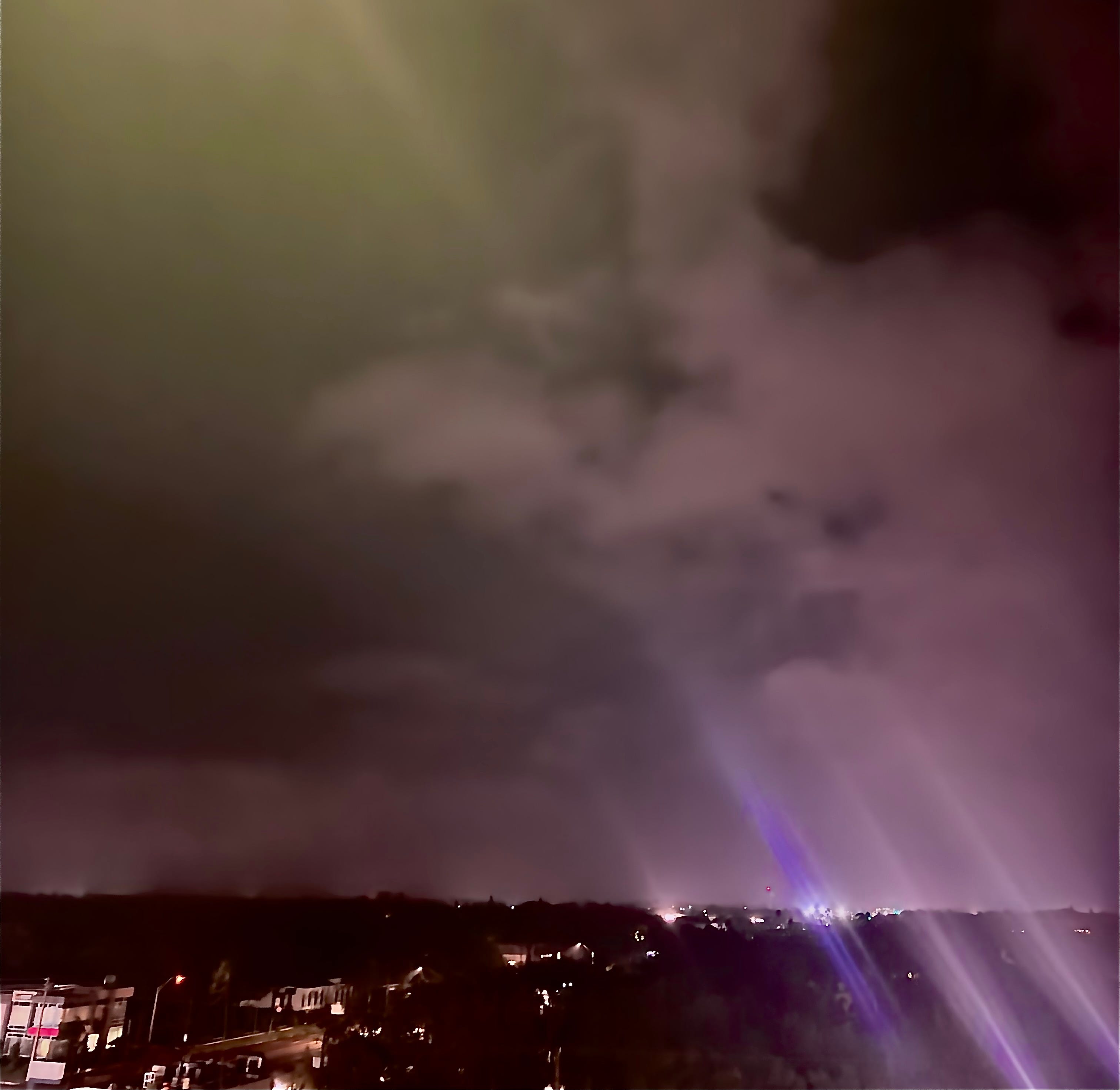
One told me later that she was so glad to have the stream because it was the only way she knew what was happening, because her family had lost power. Several others on the stream shared similar sentiments. The eye lasted longer than any others I have intercepted, or at least it felt that way. It created this beautiful, almost purple haze in the sky.
Out of nowhere, so it seemed, the backside winds came with a fierceness that seemed more powerful than the inner eye wall winds. It quickly led us to retreat to the lower floors of the garage. Around 10:30 PM, we cautiously made our way to Siesta Key, where we found debris making one of the drawbridges impassable. Powerlines were down, streets were flooded, and tree debris was everywhere.
We navigated downtown Sarasota, where the storm surge was causing major flooding, and had to be careful as we made our way through town. We were glad we knew the roads and felt comfortable in the truck with higher clearance. Another chaser called from a bridge leading to a different barrier island. We had received word that the barrier island had been hit by a major storm surge and was no longer safe to be on. He retreated as the surge made its way over the island and thankfully made it to the top of the bridge safely, where he stayed as the winds passed over.
Eventually, he was able to make his way back into the city, but the surge had eroded the island side of the bridge. Many homes and businesses on the island were inundated with several feet of storm surge, which pushed through the buildings and dragged the insides out. Peak wind gusts at the airport were clocked at 102MPH, and to our north on Anna Maria Island, they clocked gusts at 105MPH.
Around 1:02 AM on October 10th, the last of the backside outer wall rainbands made their way through Sarasota, and all went silent for the first time since the eye passed over four hours earlier. Power was out over most of the city, storm surge destroyed most of our barrier islands, and debris and flooding made it very difficult to get home. At this point, my chase partner and I called the chase and started to return to my home. There are two entrances to my subdivision, thankfully. One of them was impossible to get to because a tree had fallen across the road.
The power was out at my house, and although there were huge branches throughout the yard, making it hard to get to the front door, none of them had landed on my house.
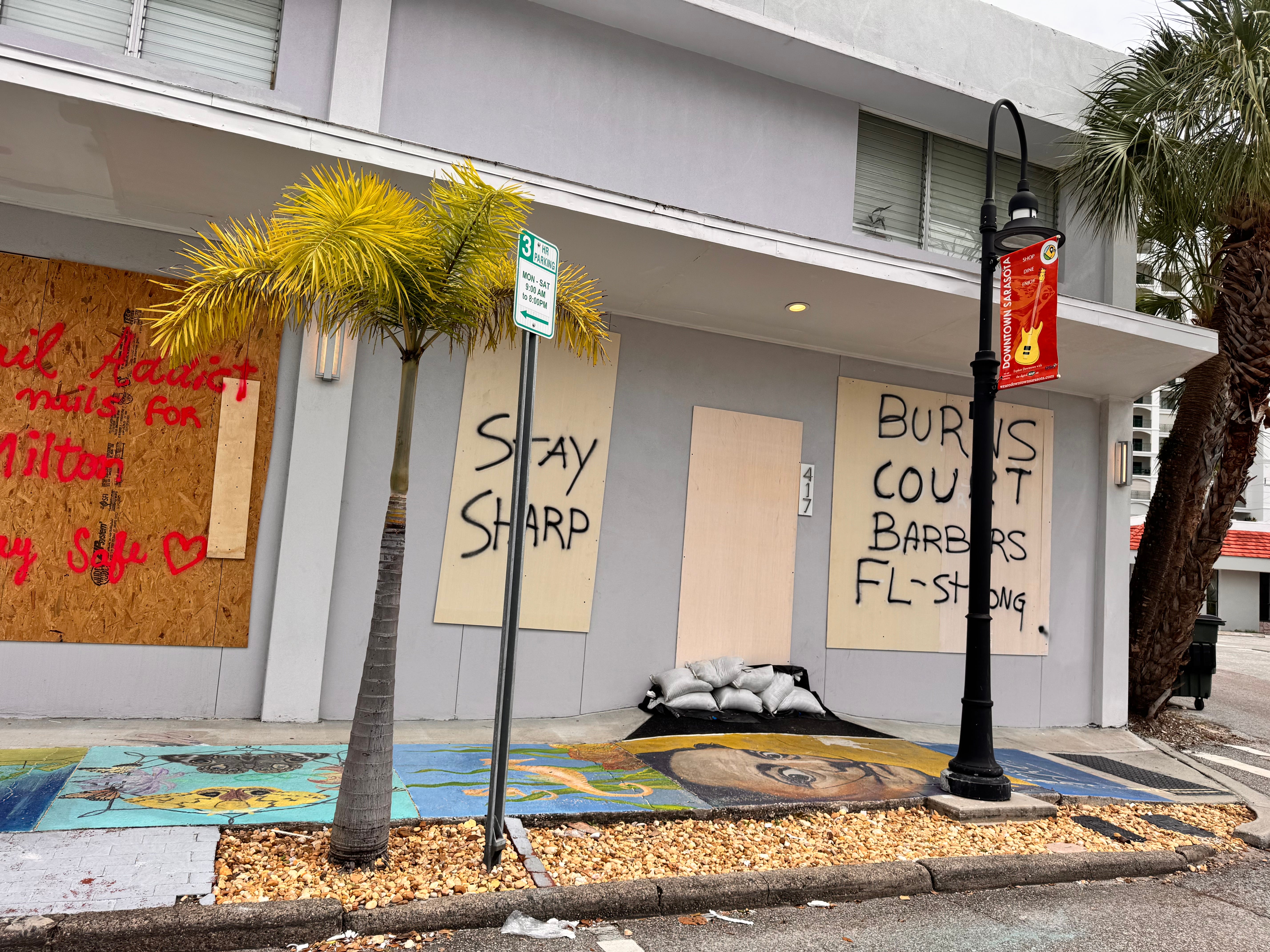
The next morning, I got up to start surveying the damage around town. I like to tell the story of the hurricane, highlighting the damage and recovery as a significant part of the narrative, and share it whenever possible. This is not to glorify, but to tell the complete story and educate people about the dangers of storm surge and strong winds, in particular.
What I found was, as expected, a ton of trees down and under that bridge that a fellow storm chaser got stuck on, which was almost completely washed away.
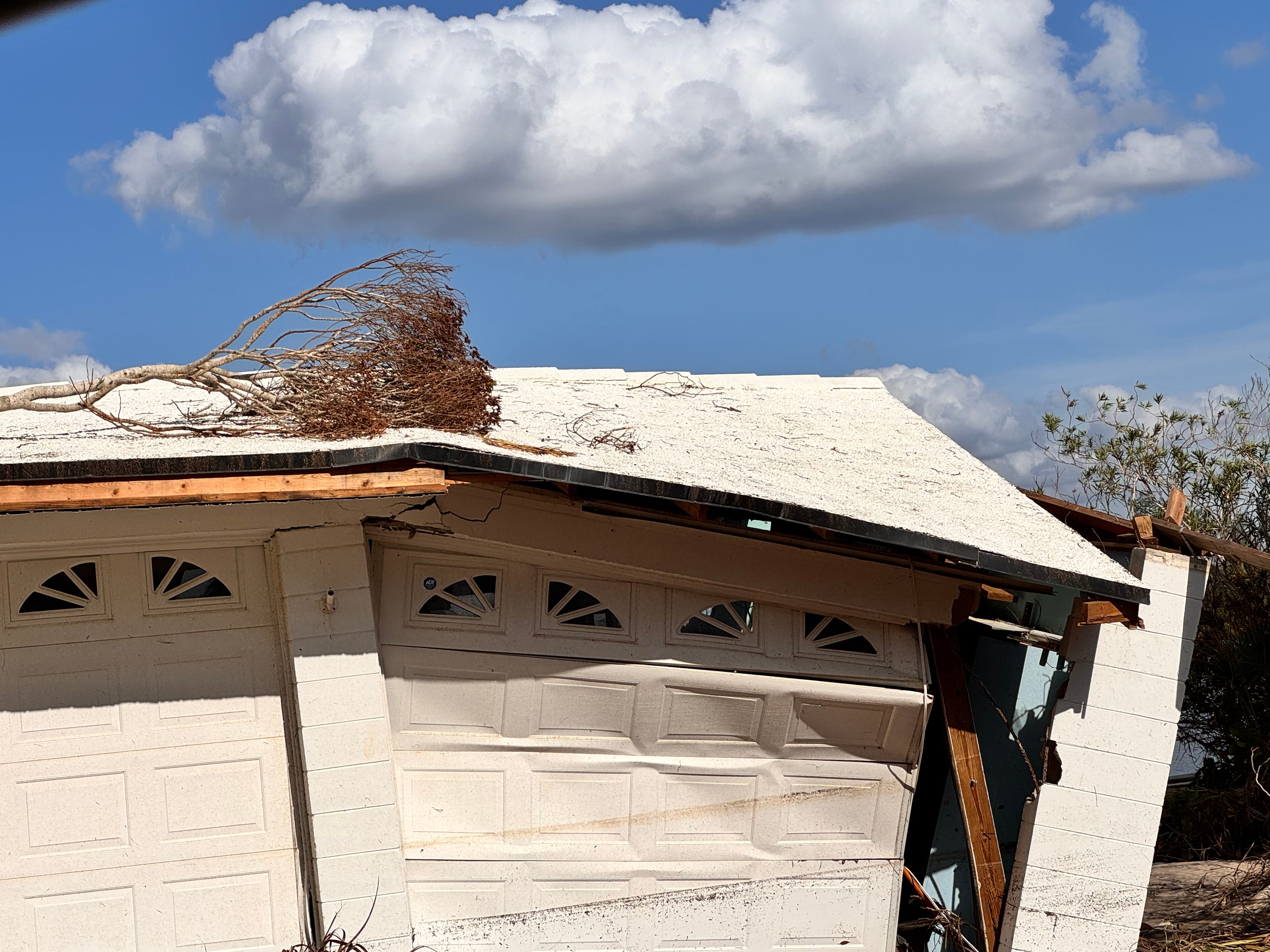
Homes on our barrier islands were full of sand and had endured water damage. Many homes had been “shifted” from their foundations. Trees had fallen through roofs and vehicles. The Aquarium (Mote Marine), where I work part-time on weekends, lost a couple of animals due to stress from the evacuation. Fuel was hard, if not impossible, to find.
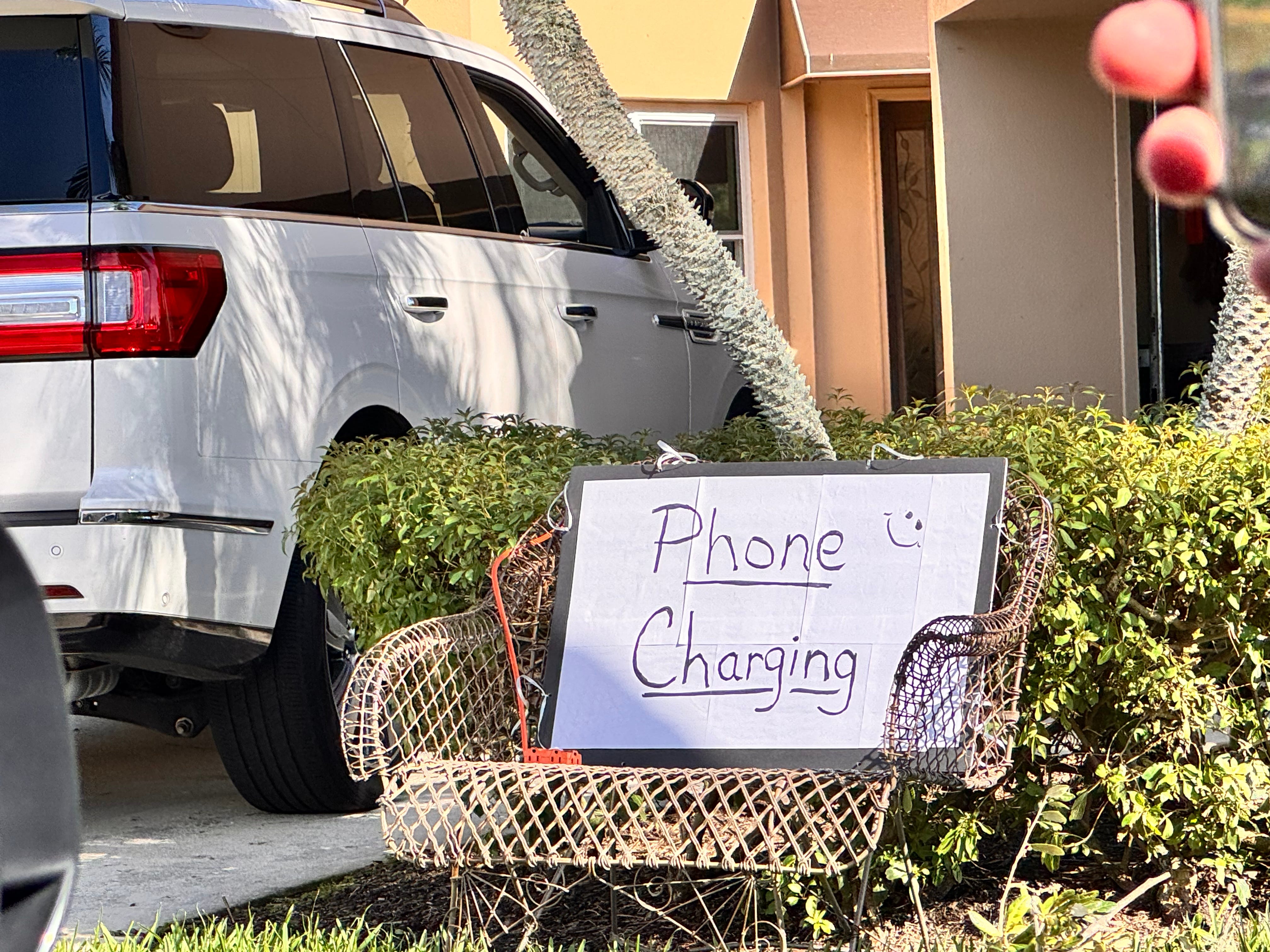
I also saw people helping people. I saw neighbors outside working together to remove debris. I saw restaurants that could open, offering a limited menu, and those that could not open offered to serve people sandwiches and other items that could be served without power.
I saw Florida Power and Light bring in trucks and linemen quickly to restore power. I saw FEMA come in and begin to help people with their claims. And- on the night of October 10, with most of the city still without power, I saw the smallest glimpse of aurora from my home, an extremely rare sight from Florida.
A few days later, Comet c/2003 A3/Tsuchinshan - ATLAS provided me with another challenge: finding it at night amidst the debris and altered landscape of our coast.
It's been almost ten months since Hurricane Milton, and the city and surrounding Gulf Coast areas are making a comeback. Several homes, restaurants, shops, and businesses will never return to the area. You can see the damage that three hurricanes have done to the Western Gulf Coast (probably most of Florida). I work about 60 miles from the coast and am surprised to see many “blue roofs” still there from all the rain and winds that came through from Milton.
As peak season is upon us, we’re all bracing for yet another season full of threats and danger. But, we are resilient and will face the season now more aware of the damage that can occur, how to prepare better, and how to support each other in the aftermath.
As a hurricane chaser, I never hope for a hurricane, especially one that will make landfall in my hometown, but it is part of life here in Florida. My why is to face Mother Nature and share what her power can bring. I do this without “hyping” the storm- I like to be realistic and a source of support for those who may need it.
I am hopeful that others will benefit from understanding the situation from both the perspective of someone who purposefully intercepted the hurricane and from the perspective of someone who lives where the hurricane made landfall.
To stay informed of the latest news on this hurricane season, visit the National Hurricane Center (NOAA) as well as your local National Weather Service Forecast Office.
"I am a teacher, currently a college professor of Education. My approach to Social Media during hurricane chases is to be real without panicking people. I like to educate people about what to expect and when. I have found so much hype leading up to hurricanes that it is disheartening. I share the NHC forecasts and explain them. I share my thoughts and explain why I feel that way, including any misconceptions."
This is EXACTLY how I do social media with my forecasts, ESPECIALLY with winter storms. Hype sells, and unfortunately my students, coworkers, and neighbors get wrapped up in what weather channels are selling them.
Instead I take the same approach as you, highlighting important information, and explaining what's essential to know.