

Two Days of Severe Weather, Then Two More Then…
The pattern is busy but are the results big Spring…or little Spring?


1. This Afternoon
SO YOU’RE SAYING THERE’S A CHANCE?
Yes. Sort of. Kind of. If you squint.
Moisture is returning north over the next day with a weak dryline pattern setting up across the Panhandles. This isn’t the kind of moisture that keeps me up at night. But there might be just enough to squeeze out a couple of higher-based storms if localized dryline convergence and mixing can muscle past a strong cap.
If something does fire, hail and maybe damaging winds would be the threats. Marginal in every sense of the word. This is the atmosphere doing the bare minimum and seeing if anyone notices.
Today on the social media profiles, I nerded out on why these setups struggle in regard to tomorrow, but it also applies to today. When 850mb winds blow hot and dry from the west and the dryline orients southwest to northeast, updrafts have to fight through a wall of dry air just to exist. The storms that do try tend to look like pencil-thin towers clawing for survival before the cap wins by sunset. It’s not impossible. It’s just not a setup that gets me reaching for my car keys.
2. Tomorrow Looks Like Last Week
I promise this isn’t a copy and paste from last week. I totally didn’t. But Mother Nature absolutely did.
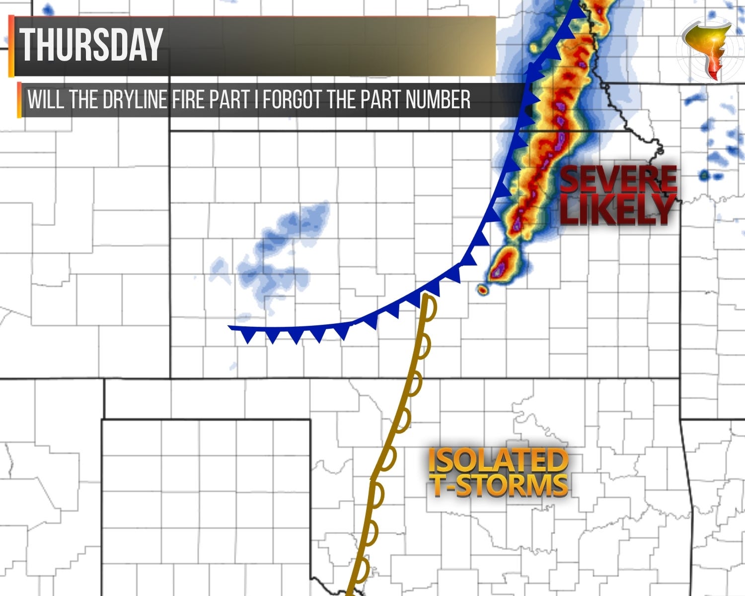
Thursday’s setup is basically last Friday’s forecast wearing a different hat. Dryline across Oklahoma and Texas, cold front pushing south through the Central Plains. Storms will fire along the front from southeast Nebraska into eastern Kansas. That’s a lock. Big hail and damaging winds are the sure bets there.
But here’s where Thursday gets interesting, and where it separates from Wednesday by a mile. The ingredients along the dryline are high-end. If a storm can fire off that boundary, it would be very isolated in an environment that favors tornadoes, giant hail, and damaging winds. The SPC has introduced a 2% CIG 1 hatch risk, basically meaning tornadoes aren’t expected but if one were to happen it’d probably be strong. I’ve been waiting my whole life for that kind of an outlook.
The problem though? Most models remain dry on the dryline. The cap is weak at peak heating, sitting right on a knife’s edge, but weak and gone are two very different things. The jet stream energy is once again tracking further north, which sounds familiar because we watched this exact movie last Friday. Storms struggled to fire on the dryline that day while the cold front did all the work.
The question I’m asking myself is whether it’s worth the drive east. Eight or nine hours in a car is a big commitment for a dryline that might not fire. The cold front will produce regardless, but that’s not the kind of day that justifies the gas money and time off of work. But if that dryline fires…
Most likely scenario: a rerun of last week. Storms struggle on the dryline, the cold front puts on the show, and it’s a very active severe weather day that isn’t necessarily a great chase day. But with ingredients this good sitting behind a cap this thin, I’m not ruling anything out yet.
Friday could bring additional storms, but odds favor the front sweeping through and pushing the action east of our chase range.
Stay tuned. Maybe Mother Nature could finally surprise us and write a new script this time.
3. The Weekend
We’re going to be out this weekend it seems in Oklahoma/S Kansas and even Texas. Another system approaches from the west with a more southerly track, which should allow for more of a traditional severe weather threat to materialize. I’ll try to bring you another newsletter Friday with more details on those risks.