

This is the Start of a Busy Stretch
Severe weather possible much of the next week...

We’ve had a pretty busy period getting ready for the upcoming storm pattern. If you haven’t done so, be sure to subscribe to us on YouTube and enable notifications so you are the first to know when we are live from the field this year.
The next couple of weeks should be on the busier end for severe weather. Let’s look at it.
Today-Thursday
Since I’m sending this so late in the day, I don’t want to belabor the point too much on today’s threat zone. The only change I’d make to this at this point is the Kansas portion of the low tornado risk zone seems far less impressive this afternoon.
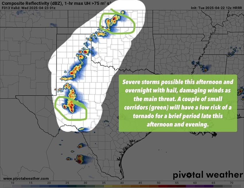
For tomorrow, we are expecting isolated storms off of the dryline at best. Assuming storms get going, they will be in an environment very favorable for supercells and severe weather.
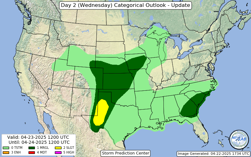
Current SPC risk probabilities put tomorrow at a slight risk. The real question is where/how many storms can get going on the dryline. Moisture is slightly limited, but I’m confident we’ll see at least a couple of robust supercells. There will be a small window for a tornado or two in the early evening before the air cools and capping increases.
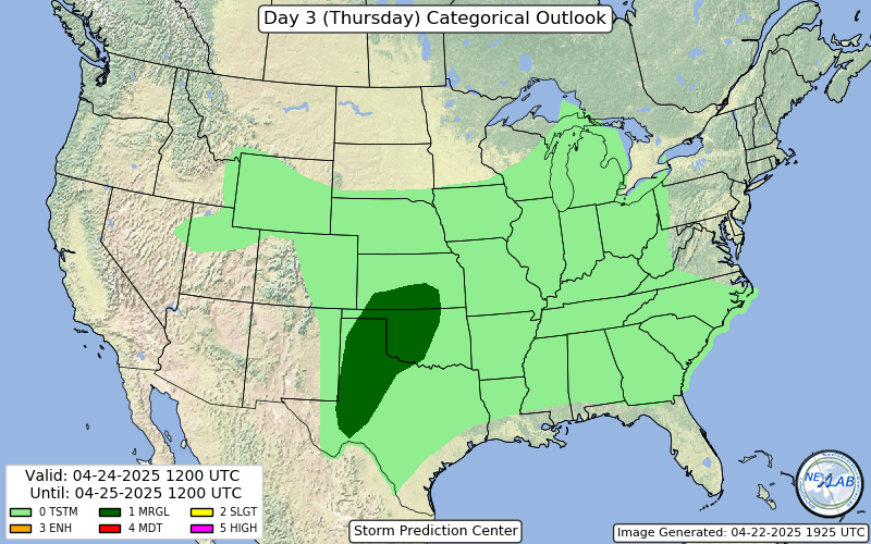
For Thursday, a lot hinges on what happens on Wednesday (which itself hinges on what happens today). Still, a subtle flow regime will exist with enough ingredients for supercells over a large area. Stay tuned to our social media profiles, especially Facebook, as we’ll be zero’ing in on the main threat areas in the next 24-36 hours.
Friday-Saturday
Both Friday and Saturday look very conditional for severe storms. There will likely be some threat both days across the Southern/Central Plains, with the caveat from the prior section that the previous days’ convection will certainly play a role in where any risk areas are.
The big change on Friday and Saturday from today to Thursday is that wind shear will be even weaker generally. This will make getting organized storms/supercells more difficult but not impossible. Any remnant boundaries or small wave features that models can’t resolve at this range will make a huge difference.
Sunday-Tuesday
The main event of this stretch will then begin in earnest from Sunday into Monday and perhaps all the way into Tuesday.
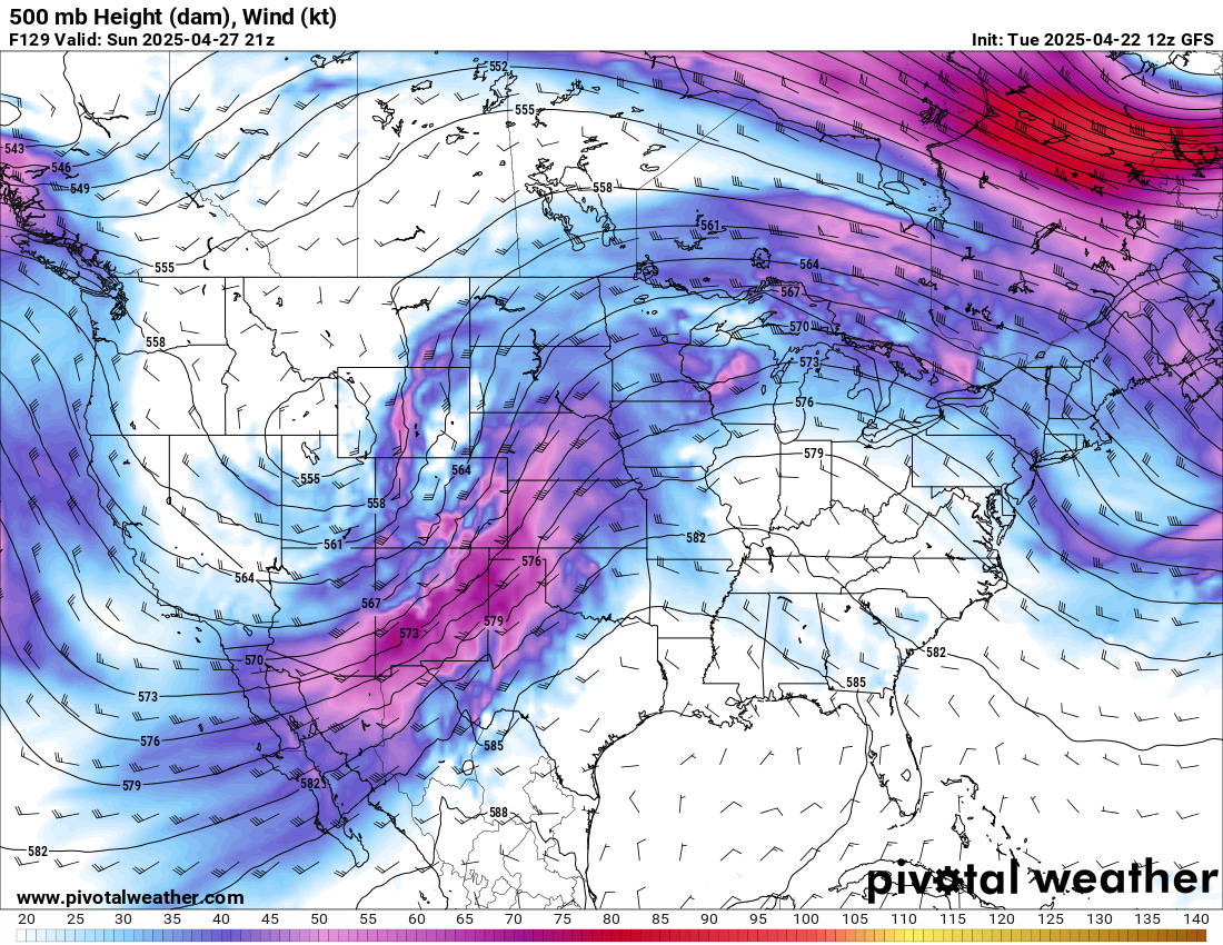
A trough will emerge out onto the Plains, with some subtle differences in how the Euro/GFS handle it leading to somewhat lower confidence than I would like at this range.
Sunday looks like a day when the dryline sets up somewhere in the Panhandles into Western Kansas, with very subtle forcing leading to only a few storms. Whichever ones form would be quite severe, capable of tornadoes and very large hail.
Monday, more of the main energy is overhead, which will allow for more storms. If there is a big risk type of day in this stretch, it is probably Monday. The environment will favor supercells, with tornadoes being a main threat. However, the exact nature of that threat will depend on storm mode and coverage.
Tuesday also bears watching as many of the same ingredients would likely still be in place, and if the slower progression of a forecast cold front comes to fruition, an unstable airmass will be in place along with moderate to strong wind shear. This could also be a big risk type of day or a cooler and dry Spring day. Unfortunately, model performance and consistency this year have been less than ideal.
Beyond
A lot of the next week looks pretty slow for severe weather, with the pattern possibly turning more active by the end of the week again. We’ll have another newsletter in about a week to talk about that.