

The Plains Winter Slumber May Be Ending
It's time for the Plains to (maybe) wake up a little bit.

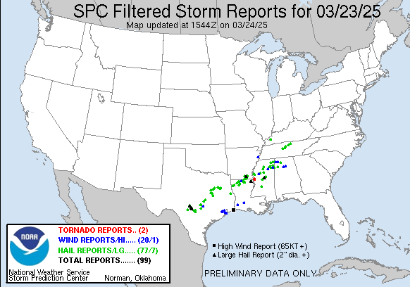
Last night was a near-Plains severe weather experience, with most of the storm reports falling just to the south and east of what we’d consider the Plains at least — maybe I’d give them Plains adjacent ratings.
But now, we’re heading into a week where it looks like we’ll finally see the transition from the dry early Spring into something more active on the Plains. Let’s take a look at it all.
The Broad Picture
To start the week off, we have a western ridge and an eastern trough, known as the least favorable pattern possible for severe weather on the Plains.

This will not last long, though.

By Thursday afternoon, a system will be crossing south over Texas, with a larger trough looming off the West Coast. This is part of the big-picture pattern change we’re seeing, with a more pronounced troughing pattern over the middle of the country.
It is likely we’ll see some pretty progressive systems in this pattern, with the risk areas mainly falling over the Eastern portions of the Plains (if not entirely east into the South). This is a classic evolution of the climate pattern we find ourselves in.

By Saturday afternoon, that trough will move over the Plains with some strong shear. Details about the upcoming weekend are still very much up in the air, as models are not handling the pattern with much agreement yet (as of this writing).
But it does seem clear we’re moving into a western trough pattern, which is the classic severe weather signal this time of year.
The Details
The first thing to note is the setup on Thursday, which likely will lead to a broad area of thunderstorm chances and at least a low severe weather risk across the Southern Plains/High Plains.

This isn’t a day I’m personally that interested in chasing, but it does help prime the pump, so to speak, for this weekend’s system.

By the weekend, the dryline sets up in Texas with a cold front diving south (on the GFS, at least). The Euro is more sharp and pronounced with a dryline over the I-35 corridor. But these details change literally from run to run with each model.
Basically, models don’t agree with themselves, much less with each other just yet.
Our pattern will favor a progressive move of this system from west to east, so I suspect an eastward bias on the dryline will be evident. Also, the cap source region is now heating big time, so expect a pretty stout EML. Storm coverage this weekend will depend on the timing/path of any shortwaves — as glancing blows may not be enough to fire off storms.
But I’m monitoring carefully.
We’ll have a video to members out sometime this week talking about my updated thoughts on the pattern ahead.
A Lightning Bonanza
May 28, 2024, was shaping up to be a day for supercells, but nothing could have prepared us for the jaw-dropping lightning show that followed. In over 20 years of storm chasing, I’ve rarely seen lightning this relentless—bolts were striking nonstop all around us. It was truly one for the books. While I’m planning to create a full compilation of all the incredible lightning from this chase, for now, here’s the story of how this electrifying day unfolded!