

The Pattern Has Changed 🍂⛈️
It's finally no longer summer. Is Fall severe weather coming?

The pattern over the lower 48 has finally changed from a summertime mode of operation to something more closely resembling fall.
I know you walked outside and felt that if you live on the Plains this morning.
That cooler/stormier vibe will be a pretty regular thing for a bit, as the upper air pattern’s shift will bring at least a quick burst of wetter weather for a large chunk of the country. The question is: will this result in some severe weather and storm chasing?
Let’s dig into the pattern change in the Big 3.
The Big Three
We wrote earlier this week about the models’ disagreements. If you followed along on social media or in our notes, you know that the GFS/Canadian’s closed-low scenario is the one that won out. Starting Friday, severe risks may exist daily across the Southern High Plains or even Central High Plains. Instability is the key question mark, as surface heating may be hard to come by. But if you get some cloud breaks throughout the day, supercells are likely given the wind shear and overall thermodynamic environment.
It has been a slowly building story, but the perpetual summertime/ridged-out pattern we just went through for a few months has resulted in widespread drought conditions across the country. This is one of the most ‘filled in’ drought maps I can ever remember, with tons of the country facing abnormally dry to drought conditions. Thankfully, for now, there’s not a lot of severe and exceptional drought. But La Niña will probably not help with preventing that over the winter.
Misinformation is rampant on social media about weather forecasts and details, which resulted in a widespread belief that Hurricane Nadine was coming for Florida on the heels of Milton. The reality is Nadine has not formed as a storm, and as of right now, there are no signs of any U.S. landfalling threats for at least another week. The dramatic pattern change that just occurred may prevent a storm from coming near the U.S. for the rest of the season. As always, make sure you vet your weather sources carefully to ensure you are getting high-quality and accurate weather forecast information from credible sources.
Science Spotlight
What can a surface map tell you about a storm environment? A lot actually.
Many forecasters take a top-down approach, which I think is generally the right decision for many reasons.
But after I leave the house and make my target using a top-down approach, I almost always pay attention to surface data and satellite exclusively. This is because what is happening up top will influence what is happening down low in real-time. Along those same lines, tornadoes are mesoscale features, and I firmly believe in paying close attention to them throughout the day.
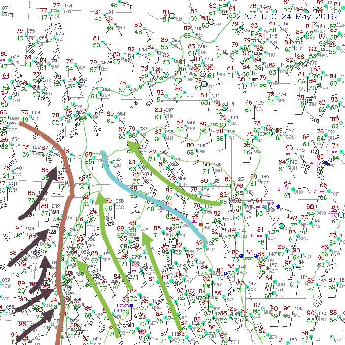
This is a surface chart with some hand analysis drawn over the top from a relatively famous chase day (you can see the date on the map). You can see the blue outflow boundary where surface winds changed and backed dramatically, which significantly impacted the day (in a big way for storm chasers). The dryline (brown line) was mainly capped off (something you would’ve seen in your morning forecast), but you could also see on the surface data how convergence would support a few storms. But a careful surface data analysis would’ve let you straight to Kansas if you understood the power of low-level boundaries on tornado formation. That’s something we’ll get into another time.
Don’t Miss This
This late April chase sequence (April 25 and 26, 2024) didn't go fully right for the crew, but there was a lot of science to see anyway.
Titans Toolkit
I am issuing my uppermost recommendation for the DJI Pocket 3 ($519) as a chase vlog camera. This camera offers a built-in gimbal for stabilization and a 1” sensor with superior video quality, and it’s so tiny and easy to use.
I recommend pairing the Pocket 3 with this Black Mist/Variable ND Filter from K&F. The wide-angle adapter from K&F will also be clutch for some storm footage.
If you wanted a tight setup for storm video, the Pocket 3 paired with your iPhone or Android device would allow you to document your chases for relatively cheap. There’s never been a better time to invest in gear to document your chases with top-notch quality.