

The Basic Parts of Supercells Explained
Learn how to read the sky…

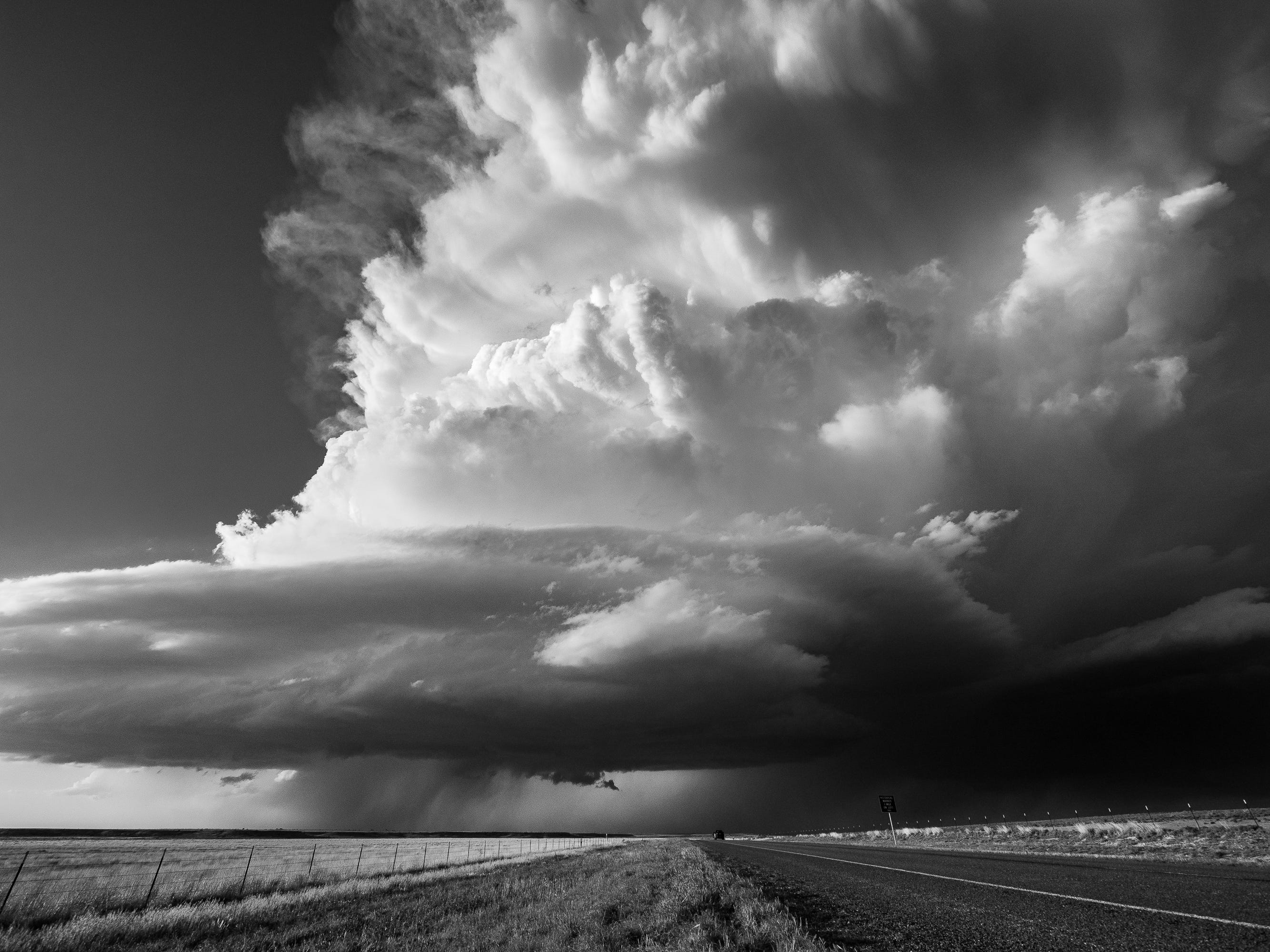
Every supercell has the same basic parts. Updraft, forward flank downdraft, rear flank downdraft. You can draw it on a whiteboard, and it looks clean and logical, like a textbook diagram that makes perfect sense.
Then you stand in front of one, and none of it looks like the diagram.
That’s the part nobody warns you about. I’ve been chasing for over 20 years, and I still have moments where I’m staring at a storm trying to reconcile what I’m seeing with what I know is supposed to be there. It happens to us all, weather breaks every rule at least once.
Supercells are structurally consistent in theory and absolutely chaotic in practice. The bones are always the same. The skin is different every single time.
So instead of walking you through a single diagram, I want to show you three real supercells. Three storms I was standing in front of. Each one looks completely different from the others, and that’s exactly the point. Once you can identify the same anatomy across storms that look nothing alike, you’re seeing what chasers see.
But first, the one thing you need to be able to spot before anything else makes sense.
The Updraft: Learn This First, Everything Else Follows
I cannot overstate how much of storm chasing comes down to watching the updraft. It’s the engine of the storm. It’s the part that tells you what’s about to happen next. If you can find the updraft, you can start reading everything else around it.
So what does it actually look like? Sometimes it looks like a dark cloud mass directly overhead, the kind that makes you instinctively look up and think “that’s not friendly.” Sometimes it looks like a towering cumulus column punching into the sky, visible from 50 miles away. And sometimes it looks like a lowered base sitting on the horizon, looking dense and organized and very much alive.
Three very different visuals, same feature. Find the updraft and you’ve found the storm’s center of gravity. Everything else orients around it.
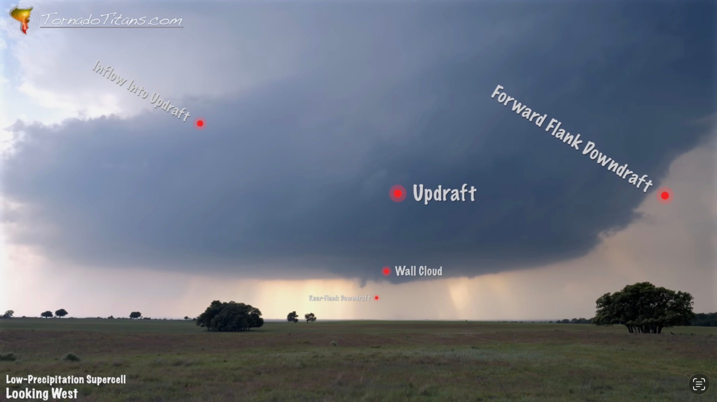
Storm #1: The Elegant One (Low-Precipitation Supercell)
I’m looking west at this storm, which is the classic chase position. And this one is gorgeous. Clean structure, easy to read. If supercells had a beauty pageant, this one would be a finalist.
The updraft is right there in front of me. And since I’m looking west, the forward flank downdraft is off to the right. That’s your rain and hail core, where most of the practical damage from a supercell happens. In this case, it’s almost transparent. This is a low-precipitation supercell, which means the forward flank isn’t dumping much rain. You can practically see through it. LP supercells are a photographer’s dream for exactly this reason.
Below the updraft, there’s a subtle lowered area. That’s the wall cloud. It doesn’t look dramatic here, but it’s rotating. I watched air rising into it, feeding the updraft above. Behind the wall cloud, on the west side, the rear flank downdraft is working its way around the mesocyclone toward the east side.
There’s no obvious inflow tail on this storm, but look at the air near the top of the updraft. You can see it streaming in and wrapping around the base. That’s inflow. The storm is pulling air into itself like it’s breathing.
And here’s the thing about this particular storm: it’s about to produce a tornado. Right after this moment, a funnel began forming. Rising motion spiraling up into the base. The base itself is starting to look smoother, more laminar. That smoothness is a sign. When the bottom of a storm starts looking polished instead of ragged where there’s a lot of motion, it usually means rotation is tightening. I’ve learned to pay very close attention when that transition happens.
This storm is textbook. You can see every feature, label every part. Which is great, because the next one is going to be less easy.
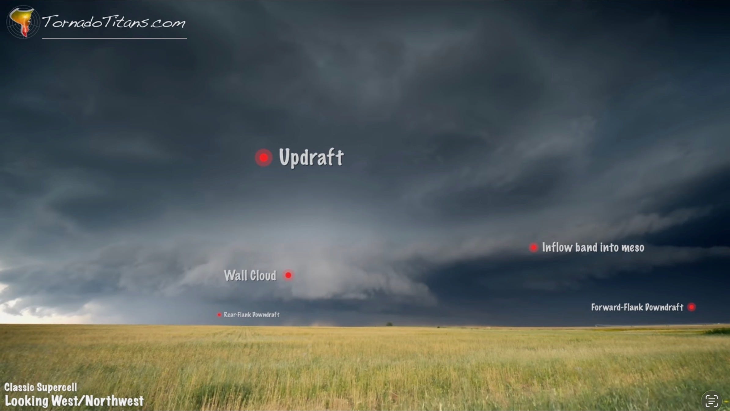
Storm #2: The Brawler (Classic Supercell)
I’m looking northwest at this storm and it is a completely different animal. If Storm #1 was elegant, this one showed up looking for a fight.
The updraft is there, but the whole scene around it is busier, messier, more aggressive. Off to the right, the forward flank downdraft is dark. Really dark. That rain and hail core is loaded and it looks menacing even from a distance. Classic supercell behavior.
Now here’s where it gets interesting. There’s a prominent wall cloud hanging below the updraft base, clearly lowered and clearly rotating. Behind it, the rear flank downdraft is surging. I can see a shelf cloud being pushed outward on the left side of the lowered area, where the cloud slants away from the precipitation. That shelf is the RFD making its presence known, physically shoving air outward as it wraps around.
In the middle of all this, rotation. Not dramatic, not photogenic, but visible. I can see dust getting kicked up near the surface as the rear flank downdraft curls around. And the wheat in the foreground? Blowing straight into the storm. That’s inflow at the surface, feeding the updraft, keeping the whole machine running.
This storm also produced a tornado after this moment. But I want you to notice something: when you see a dark, surging RFD wrapping behind a visible wall cloud like this, the tornado that follows is almost always rain-wrapped. Nine times out of ten. That gorgeous structure you’re watching is about to disappear behind a curtain of rain, and whatever happens next, you’re not going to see it. That’s exactly what happened here.
Just because a storm is classic now doesn’t mean it’ll stay that way. Supercells change their appearance, sometimes many times over their life-cycles.
Two storms, two tornadoes, two completely different visual experiences. And we’ve still got one more.
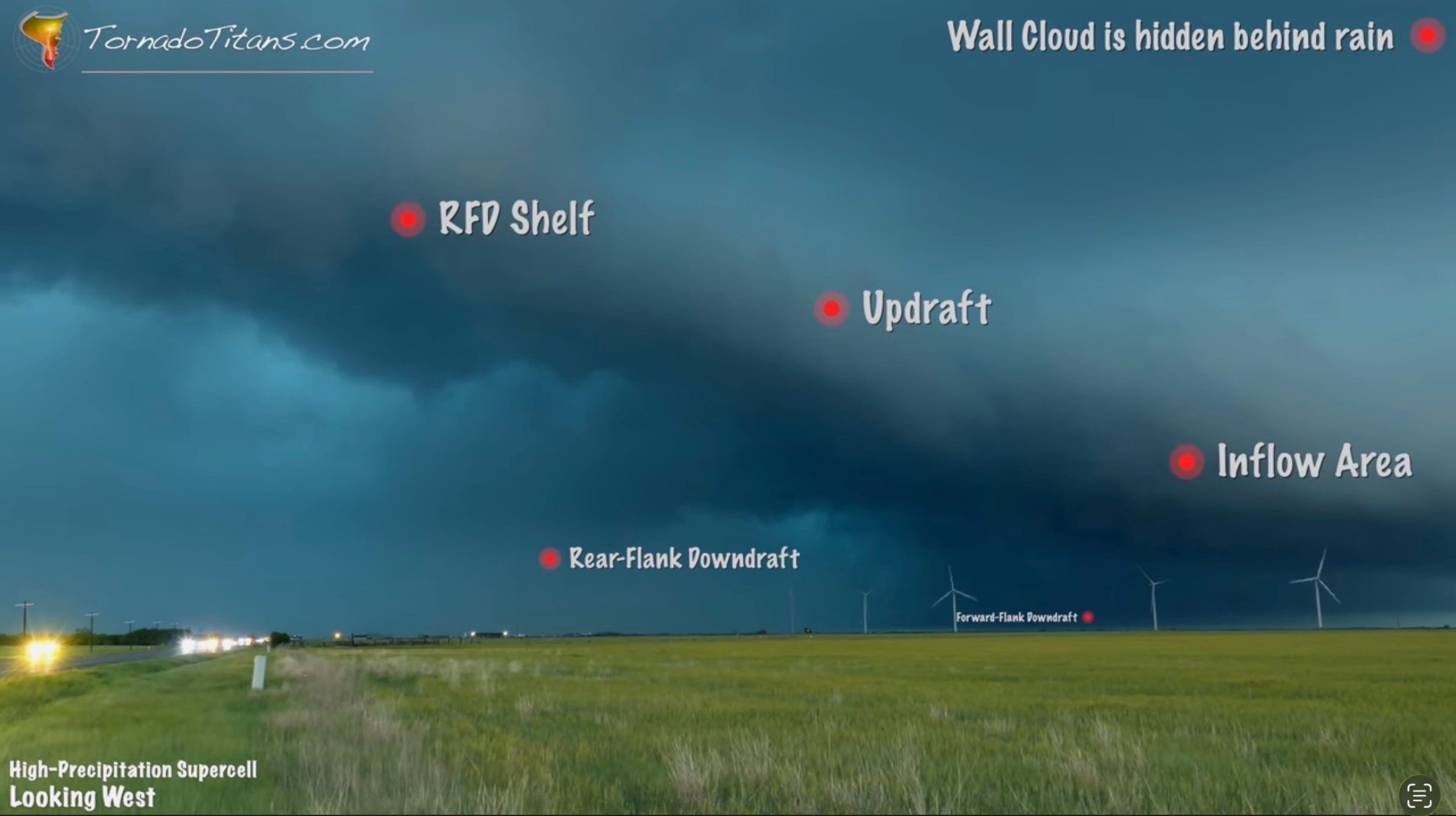
Storm #3: The Chaos Monster (High-Precipitation Supercell)
This storm looks nothing like the first two. Absolutely nothing. If I showed you all three side by side, you might not believe they share the same anatomy. This is a high-precipitation supercell, and it is pandemonium.
The updraft is massive. It’s right in front of me, enormous and imposing, the kind of storm that makes the sky feel like it’s lowering onto you. The forward flank downdraft? It’s back there somewhere, buried behind layers of rain and murk. Hard to see, hard to separate from the rest of the storm. HP supercells don’t give you clean lines between features. Everything bleeds together.
The rear flank downdraft is the wildest part. There’s a glowing area of precipitation that marks it, but there’s also this dark mass moving from right to left. That’s the RFD surging around the mesocyclone. And because this is an HP storm, the tornadic area is already being swallowed by rain.
The wall cloud? It was there. Then it wasn’t. The rain just ate it. Above me, a rear flank downdraft shelf cloud is pushing outward, but it’s not well-defined because honestly, nothing about this storm is well-defined. To the right, inflow is still feeding in, and this thing just went completely, hopelessly rain-wrapped.
If there’s a tornado in there, and the storm absolutely has the structure to produce one, nobody is seeing it. This is the kind of storm where you have to trust your radar and your instincts, because your eyes aren’t going to help you.
You Can Do This
Three supercells. Same parts list. Completely different presentations. That’s the reality of reading storms in the field. The diagrams give you vocabulary. The real world gives you a thousand variations on the same theme and asks you to figure it out in real time while the wind is picking up and the sky is turning green.
I love it. Every single time.
The more storms you watch, the faster you’ll start recognizing the updraft, the downdrafts, the inflow, the rotation. And once those pieces click, you stop seeing a wall of chaos and start seeing a machine with moving parts. It doesn’t get less awe-inspiring when you understand it. If anything, it gets more so. Knowing what you’re looking at makes the spectacle bigger, not smaller.
Want to see all three storms in motion? The full video walkthrough is above, where I point out every feature in real time as the storms evolve.
Love this! Thank you!
As a newer tornado/storm enthusiast, it was awesome to read and share the sentiment of : I did all of this research yet, I still can't make up what I'm looking at half the time in the 'real world'. This was such an awesome and helpful article, thanks a ton!!