

💨🌪️ Significant Threat of Severe Storms Today
De-De-Derec-Derecho?

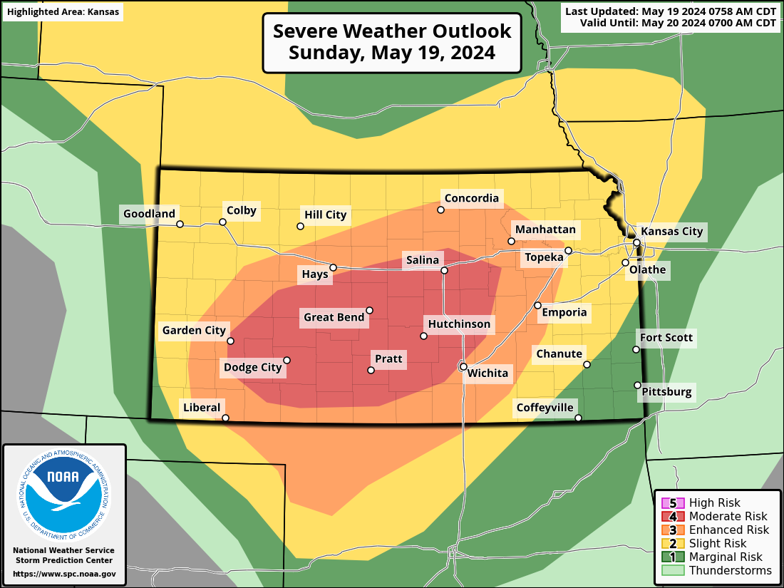
Severe thunderstorms are expected across parts of Kansas into northwest Oklahoma from late afternoon into mid-evening, with potential for a derecho. Destructive wind swaths of 80-100 mph may occur, with localized extreme gusts exceeding 100 mph possible. Huge hail and a few tornadoes are also anticipated.
Locations:
Primary Risk Area: Southwest to Central Kansas
Secondary Risk Area: Northwest Oklahoma, Western Oklahoma
Threats:
Destructive Wind Gusts: 80-100 mph, with localized extreme gusts exceeding 100 mph.
Large Hail: Particularly with initial supercell development.
Tornadoes: A few tornadoes are possible, especially with robust supercells in the evening.
Timing:
Storm Initiation: Late afternoon
Peak Intensity: Late afternoon to mid-evening
Meteorological Discussion:
Synoptic Setup:
A strengthening upper-level jet across the Southwest, nosing over the southern Rockies, will aid in dryline sharpening by late afternoon.
A strongly unstable airmass will develop, with an MLCAPE of 2500-3500 J/kg becoming common due to hot surface temperatures and a plume of mid- to upper-60s surface dew points.
Storm Development Regions:
Initial high-based thunderstorms should form off the Raton Mesa behind the dryline.
Other storms will form along the dryline near the Texas Panhandle/western Oklahoma border and in the north-central Kansas vicinity near the warm front.
Storm Modes and Evolution:
The far southern dryline storms in northwest Oklahoma and near the warm front in Kansas should remain semi-discrete longer and will be most capable of producing very large hail and a couple of tornadoes.
Between these two corridors, a mix of outflow-dominated clusters with embedded supercells will move east-northeast during the evening, evolving into linear bowing segments.
Forecast soundings indicate potential for intense rear-inflow jet development, suggesting a probable scenario for prolific, organized, severe wind swaths.
Central Great Plains Low-Level Jet Influence:
The low-level jet will strengthen during the evening, resulting in a large mesoscale convective system (MCS) with embedded bowing structures persisting after dusk.
CAM guidance suggests diminishing intensity as MLCIN rapidly increases across much of Oklahoma into at least southeast Kansas. That may not match reality, though, as it seems somewhat likely we’ll see storms persist well after dark, given strong MCS dynamics that will likely take shape.
Western Nebraska to Western/Central South Dakota:
Scattered thunderstorm development is expected along the northern portion of the dryline during the late afternoon to early evening as a narrow plume of mid- to upper-50s surface dew points spreads north.
With a more confined and modestly buoyant warm-moist sector relative to Kansas southward, the overall threat should be isolated to scattered large hail and severe wind.
Live Streaming Today
It’s a good day to subscribe to us on YouTube, as we begin a marathon period of storm chasing with plans to stream most days. Ok, now back to the forecast!
Technical Discussion:

The humble beginnings of our line of storms should be ongoing at 2-3 p.m. this afternoon as initial very high-based storms form off of the Raton Mesa in drier air behind the technical dryline. These storms will gust out very quickly, and cold pool generation will be robust as these storms move upstream. Given anvil blowoff locations, I am somewhat becoming convinced no storms will form on the warm front to the east, given stronger capping. Still, it is possible a storm or two could get going in C/N Kansas this afternoon, and I’m just hallucinating solutions that won’t exist.

By evening, I suspect the radar maps will look a lot like this: A storm or two will have formed off of the dryline in W/NW Oklahoma, and a monster line will be ongoing across Kansas. That linear complex will be capable of producing extremely destructive winds (80+) miles per hour across a large swath of land. Yes, folks, it’s derecho time, possibly today.

Before we get too hyped and start throwing around big words like candy, let’s look at the environment by evening. Increasing capping will almost certainly exist as the sun sets, which may mitigate or modulate the most damaging winds from reaching the surface of Kansas’s linear complex. However, looking through models today, the dynamics that’d help persist a large MCS will certainly be in place throughout the evening. Some tornadoes would be possible on the front end of the line and in the comma head of the MCS to the north if storms can maintain that surface-based nature.

Further south, the cap will also increase by sunset, so the persistence of any supercells is somewhat in doubt. If a storm can maintain a surface-based presence by sunset, the environment is very favorable for a quick succession of tornadoes. My general thought is the dryline fires a supercell at 4, and we watch it fade away at/near/after sunset. If there is a tornado off the dryline today, it’ll likely be due to a storm-scale process like a favorable merger and not the overall dynamics of the day.