

Milton's Landfall + A Signifcant Tornado Outbreak
Florida can't catch a break.

This has been one of the more ridiculous weather days I can remember recently. As residents were likely planning to make their final preparations for Hurricane Milton across Florida, a significant tornado outbreak with strong to possibly even violent tornadoes took shape through much of the day.
And now, major category 3 Hurricane Milton is moving ashore as I write this.
This storm has been well forecasted in terms of its practical human impacts thus far. Significant kudos should be given to the National Hurricane Center and local National Weather Service forecast offices for their work. Now, let’s get to the big three.
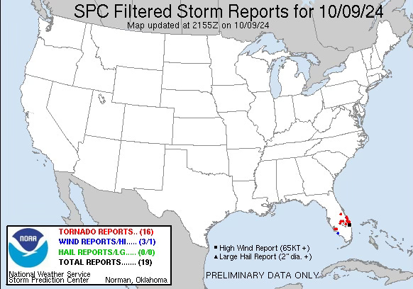
The Big Three
A significant tornado outbreak occurred today across much of Florida. Multiple large tornadoes were caught on camera from coast to coast, with significant damage reported. There have been 16 tornadoes reported thus far, but that is likely a severe undercount as several tornadoes occurred over open land, which are likely not quite in the database.
The outbreak's parent storm, Hurricane Milton, is making landfall near the Tampa Bay metro area. This will be a multi-billion dollar disaster, with storm surge and wind damage likely impacting a broad swath of the state. Additionally, flash flooding is an increasing concern as this storm moves ashore.
It’s also worth noting that, outside of the Florida breaking weather situation, the rest of the country is almost historically quiet. There are some dense fog advisories and freeze warnings out there, I guess.
Science Spotlight
Why were there so many tornadoes in Florida today? What made Hurricane Milton’s pre-landfall environment so favorable for strong tornadoes? Let’s break it down.

Typically, there is a lot of wind shear ahead of hurricanes, and today’s environment is no different. What seemed different this time around was the orientation of the shear in relation to the storm motion, as well as an uncharacteristic thermodynamic environment for a landfalling tropical system.
Initially, ahead of Milton, there was some intense surface heating alongside a very rich boundary layer with upper 70 dewpoints. This allowed intense updrafts to take shape with ample 3CAPE (170 j/kg). When mixed with effective SRH values of over 120 m2s2, this environment was primed for large tornadoes.

I think the wind shear, oriented favorably over a larger area, along with favorable low-level backing of winds (you don’t always see this much turning with tropical systems), created an environment that spawned today’s tornadoes.
Don’t Miss This
Be sure to check out our latest video on YouTube and subscribe while you are there!
BONUS: Skywatching Alert
Two important events are coming up on your astronomical calendars to look out for.
The first is the possibility of a brilliant Northern Lights display that may rival May’s display tomorrow night (October 10).
Secondly, a naked eye visible comet will be visible just after sunset starting on October 11-12 and lasting until October 20. Look to the west just to the right of Venus.