

Historic Winter Storm Set to Impact Southern U.S.
This one is packing a punch and will leave a lasting mark…

It’s not that dramatic to say we are now about 24 hours away from the start of what will be the defining storm system of the Winter season for much of the country, and a system many will refer back to for years to come. Let’s get into the details.
LIVE CLASS SATURDAY AT NOON
While you are getting snowed in this weekend, join us for a live class this Saturday at noon. We’re going to teach the basics of weather models and some of my go-to graphics on storm setup days. If you’ve always wanted to learn, these classes are THE PLACE to do so!
1. Historic Storm System to Bring Significant Impacts
The wide-ranging nature of this storm system, with impacts from the Mid-Atlantic to the Desert Southwest AT THE SAME TIME, is very rare. If one ever wondered what a tropical fetch of Pacific moisture overrunning a bitterly cold Siberian airmass looks like, you’ll get your wish this weekend.
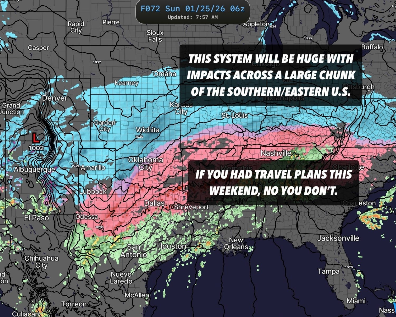
The top line is this: Irregardless of what type of precipitation falls where you are and how much, this system will create major impacts across a broad swath of the Southern/Eastern U.S.
Travel will be difficult to impossible, power outages will be widespread, and damage to trees and other exposed surfaces, such as power lines, will be catastrophic.
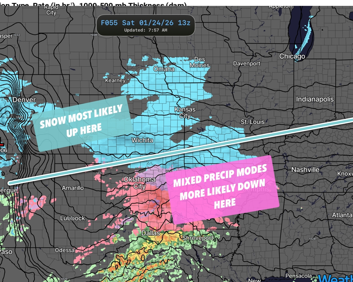
Of note is that the warm nose associated with this system’s shallow arctic airmass keeps coming in stronger from run to run on models. This is leading to a northward migration of the “snow only” to “winter mix” line. The mixed precipitation areas will render most forecast graphics from models of snow/ice obsolete.
The mixed precipitation areas, which right now are south of a line from basically Albuquerque to Dalhart, TX, to Enid, OK, to Miami, OK, and then towards the Ohio River Valley region, will be difficult to pin down in terms of how much of what falls. The variability from mile to mile may actually be real in these regions — I’ve done enough of these to know that it is largely a fool's errand when you are dealing with 1°C changes in temperature, a few thousand feet up, that can change entire outcomes for a system.
What is obvious is this (once again): The practical impacts in these regions will be brutal. The big concern I have is for a widespread ice storm, as ice accretion should be VERY efficient in the cold arctic airmass at the surface.
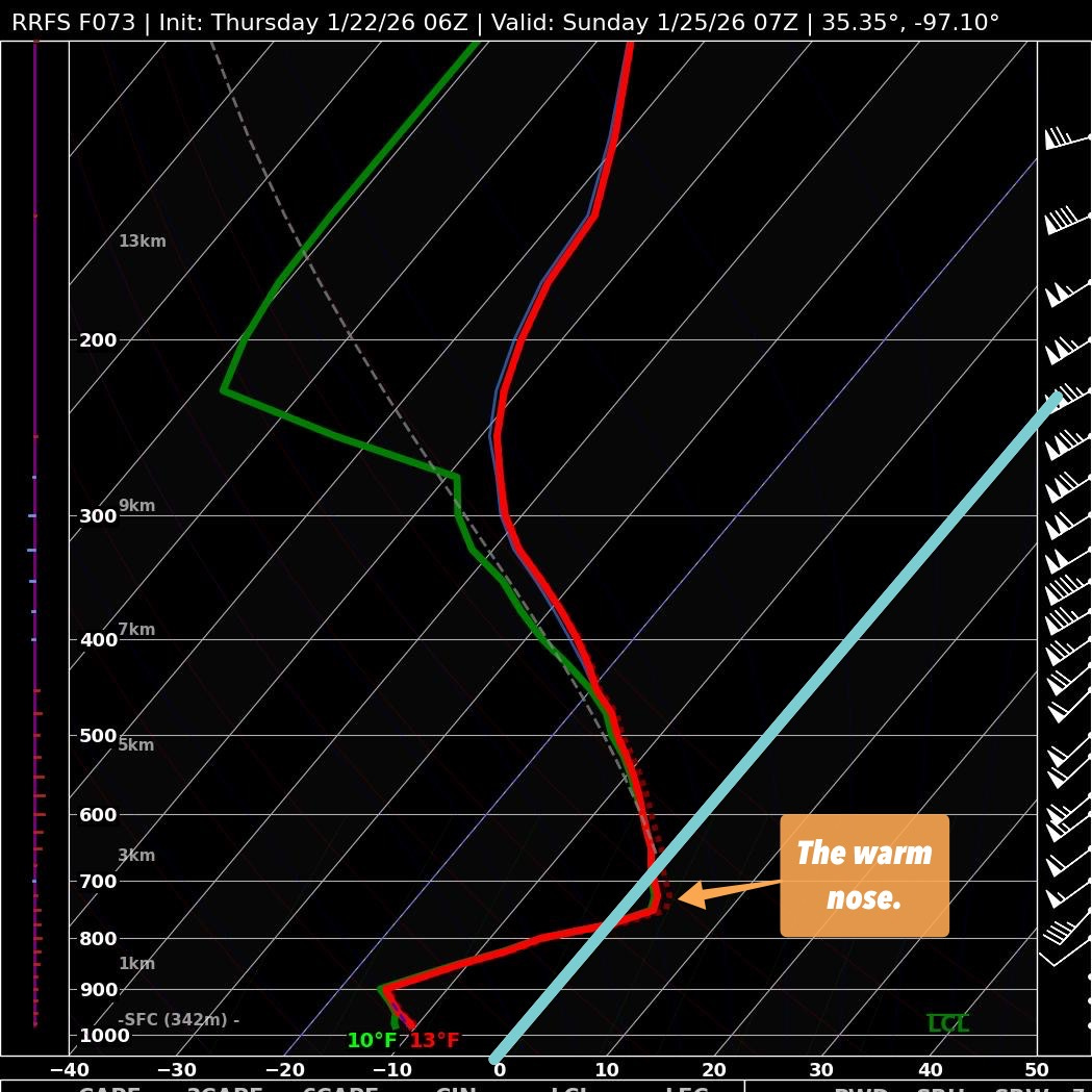
That small area above freezing, somewhere about 2km above the surface, is going to wreak havoc on snowfall forecast maps generated by weather models. I am repeating this because I am worried folks may be caught off guard by freezing rain and ice accretion when they were expecting more of a snow event.
Historically, models have difficulty with this layer of warm air aloft, which creates uncertainty about precipitation type and totals in any given area.
What isn’t in doubt is that a lot of water will fall over a large area of subfreezing air. This is rock solid from run to run and from model to model.
2. The Tornado X-Factor
Just in case you want to think of warmer times or in case you want to brush up on your Spring storm season knowledge, our newest video deals with the hidden X-factor in storms and how it impacts tornado formation.
Check out our video on that here:
3. Severe Weather Masterclass: Basics of Forecasting
Did you miss our first free live class last weekend? You can catch its replay on our channel for a limited time right now.
JUST AS IMPORTANTLY, our next free live class is this Saturday at noon on the basics of weather models. In this class, we’ll talk about the types of models, what each is good at, dive into individual model biases, and we’ll also talk about my go-to model graphics on storm chase days. This is an ideal follow up to last week’s class and I highly recommend it for beginners or even folks who have been doing this stuff for awhile. There’ll be good information shared!