

Five Charts That'll Have You Forecasting Severe Weather by Tonight
You don't need a meteorology degree. You need about 10 minutes and these five free tools.

Every storm chaser you’ve ever watched on video looked at these exact charts before they left the house. Not all of them. Not the deep-dive stuff. These ones. The same five graphics, in the same order, every single chase day.
Am I oversimplifying? Yeah, I am. Is this a framework of a technique every storm chaser on planet earth uses? Yes, yes it is.
The thing nobody tells you about severe weather forecasting is that the baseline version of it is shockingly accessible. You’re not going to come out of this as a meteorologist. You’re not going to nail a tornado forecast on your first try. But you are going to look at a map of the United States and know — with actual reasoning behind it — where the action is most likely to occur today. That’s more than most people ever get to.
Here’s the whole process, start to finish.
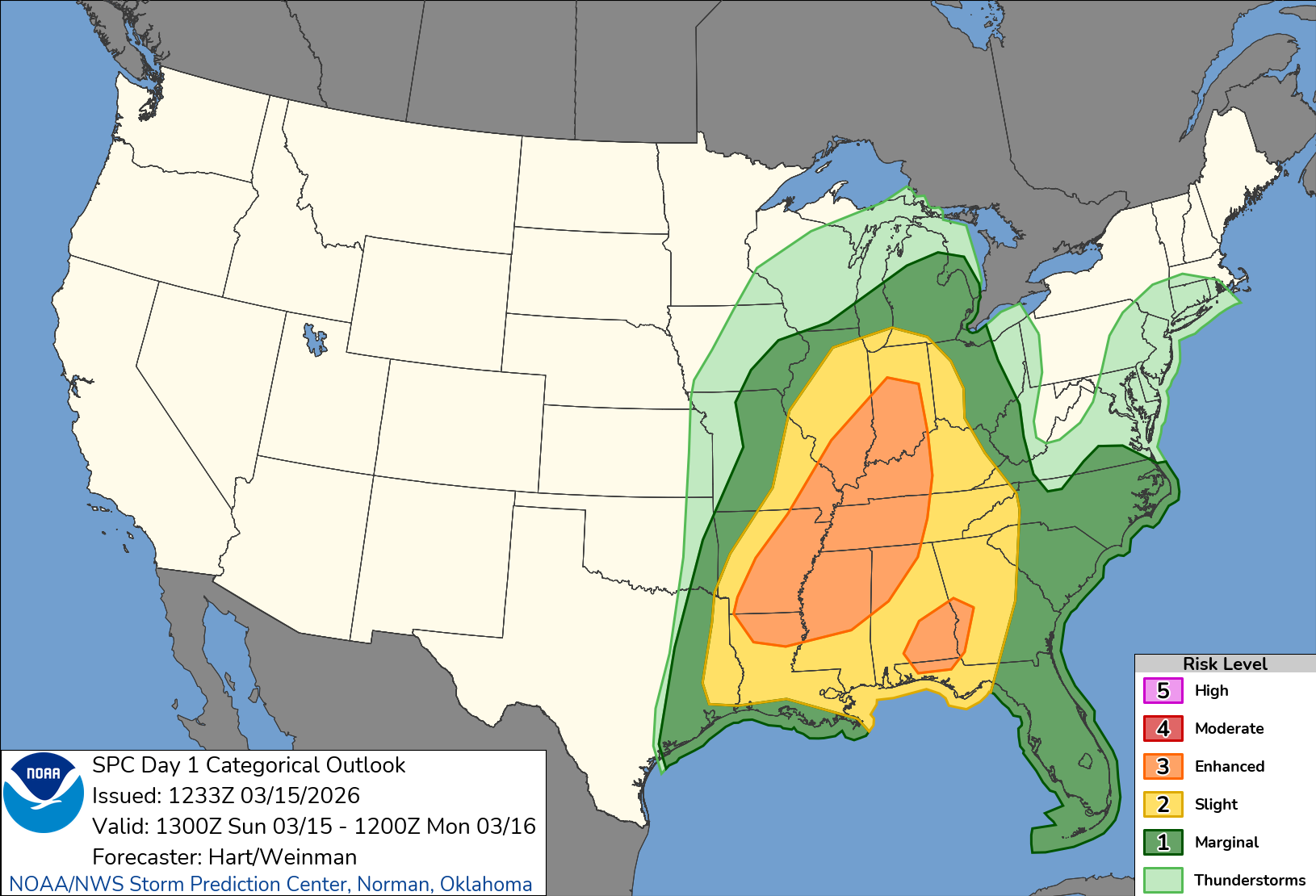
1. Start Where the Pros Start: The Storm Prediction Center Outlook
Before you touch a single model or chart, go to the Storm Prediction Center’s Day 1 Outlook (spc.noaa.gov). This is where NOAA’s actual severe weather forecasters lay out where they think the risk is today — highlighted right on the map with a color-coded scale.
You’ll see categories from “General Thunderstorms” up through “Marginal,” “Slight,” “Enhanced,” “Moderate,” and “High.” You can also toggle between tornado, hail, and wind risk individually. Don’t get hung up on what the exact percentages mean right now. Honestly, that rabbit hole goes deep and the definitions shift depending on who you ask. Just know: brighter colors, bigger risk. That’s your starting zone.
This is your “where should I even be looking?” answer. Bookmark it. It’s your first click every single day during storm season.
Sidenote: You don’t actually know more than the folks at the SPC. Trust me. They’re smarter than you when it comes to severe storms in every way.
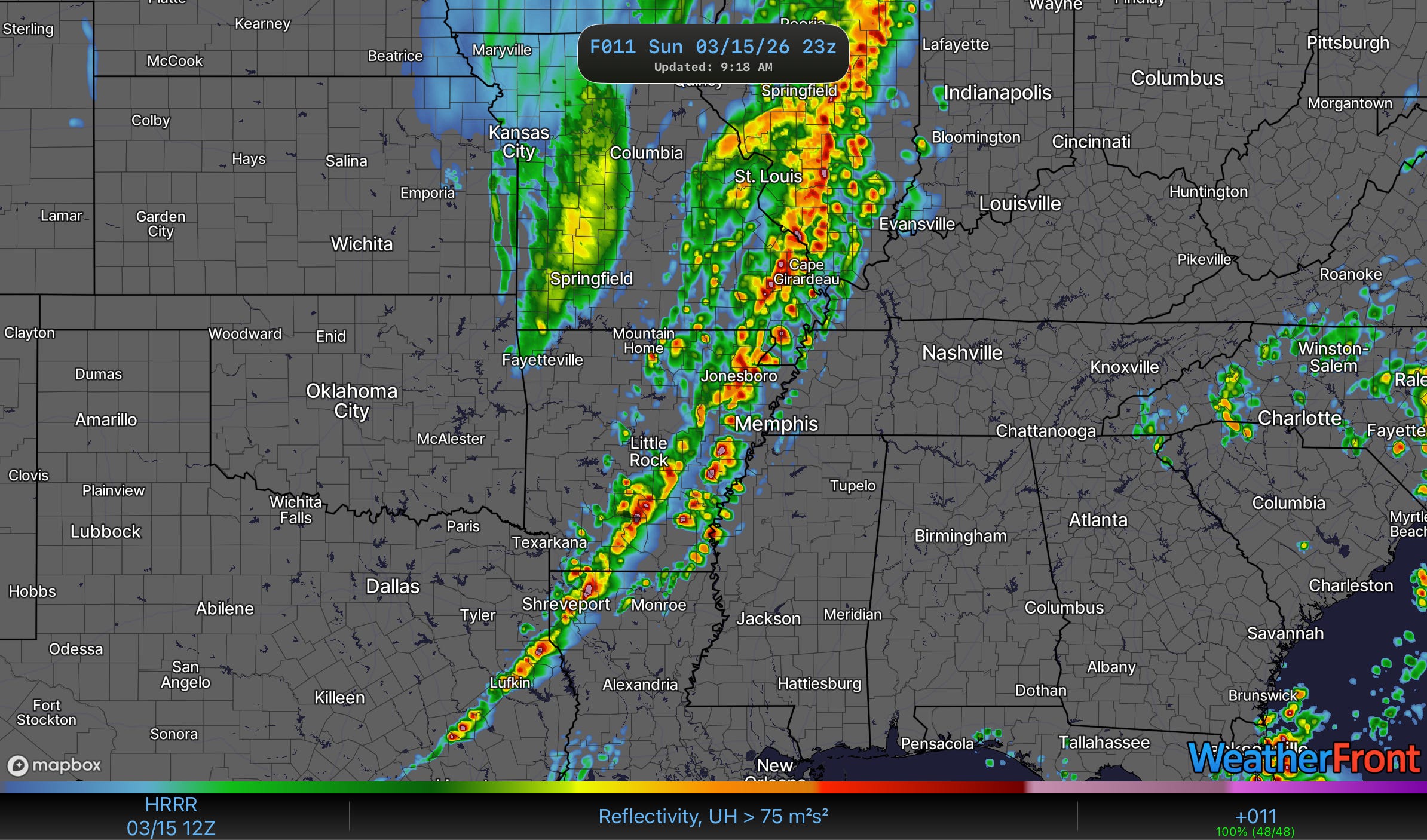
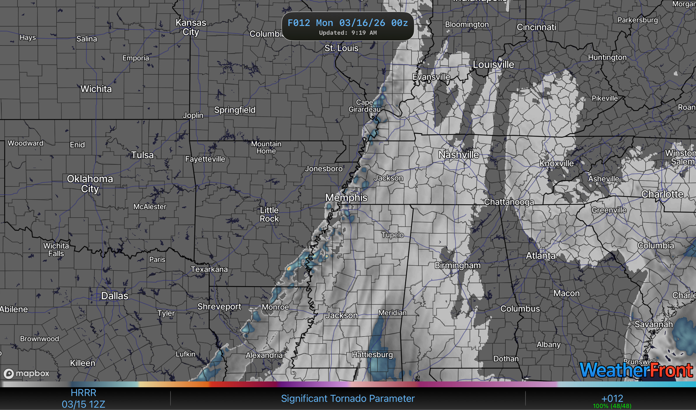
2. See Where Storms Actually Form: HRRR Reflectivity + Updraft Helicity
Now head to a modeling site. We recommend either Pivotal Weather (pivotalweather.com) or the WeatherFront App. There are a bunch of great model-viewing sites out there, but Pivotal is clean and free and what a lot of chasers use daily.
You’re going to pull up the HRRR model — that’s the High-Resolution Rapid Refresh, and it updates every hour, which means it’s the closest thing to a real-time storm simulator you’re going to get. Find the product called “Reflectivity + Updraft Helicity.”
Here’s what you’re looking at: The reflectivity shows you where storms are predicted to form. Those bright blobs are thunderstorms on the model. But the real magic is the updraft helicity — those little streaks running through the storm cells. When you see a streak, the model is saying this storm is spinning. That’s your signal for a potential supercell.
One important caveat: the HRRR changes dramatically through the day. A morning run might show storms in a completely different spot than the afternoon run. That’s normal. You’re looking for trends and general areas, not GPS coordinates.
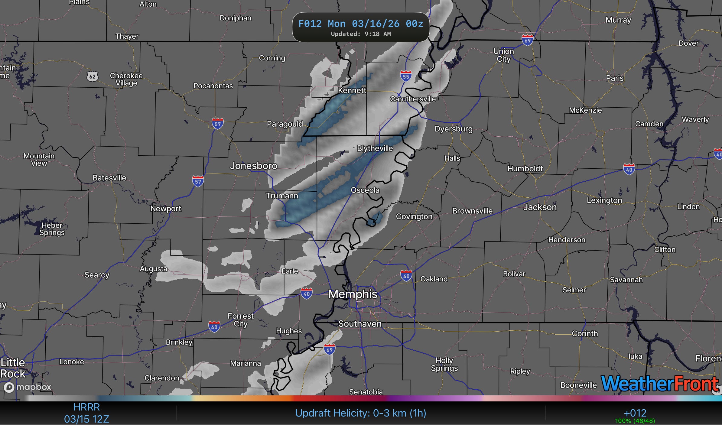
3. Find the Rotation: 0-3km Updraft Helicity
Stay on Pivotal Weather and switch to the “Updraft Helicity 0–3 km” product. This one zooms in on what’s happening in the lower atmosphere specifically.
Those streaks you see here? The model is projecting low-level rotation — the kind that’s directly tied to mesocyclones and, eventually, tornadoes. Compare this to the reflectivity chart you just looked at. If the storms from chart #2 are discrete, individual cells (not a big squall line) and they’re showing strong low-level vorticity streaks here, you’re looking at a setup that could produce serious weather. You can get serious weather with lines for the record as well, but the forecasting there gets a little trickier and we’re not touching that with a 9 foot pole just yet (but soon).
What you are doing is building a picture now. SPC told you the general area. The HRRR told you where storms form. This chart is telling you which of those storms might be doing something especially dangerous. Easy enough so far?
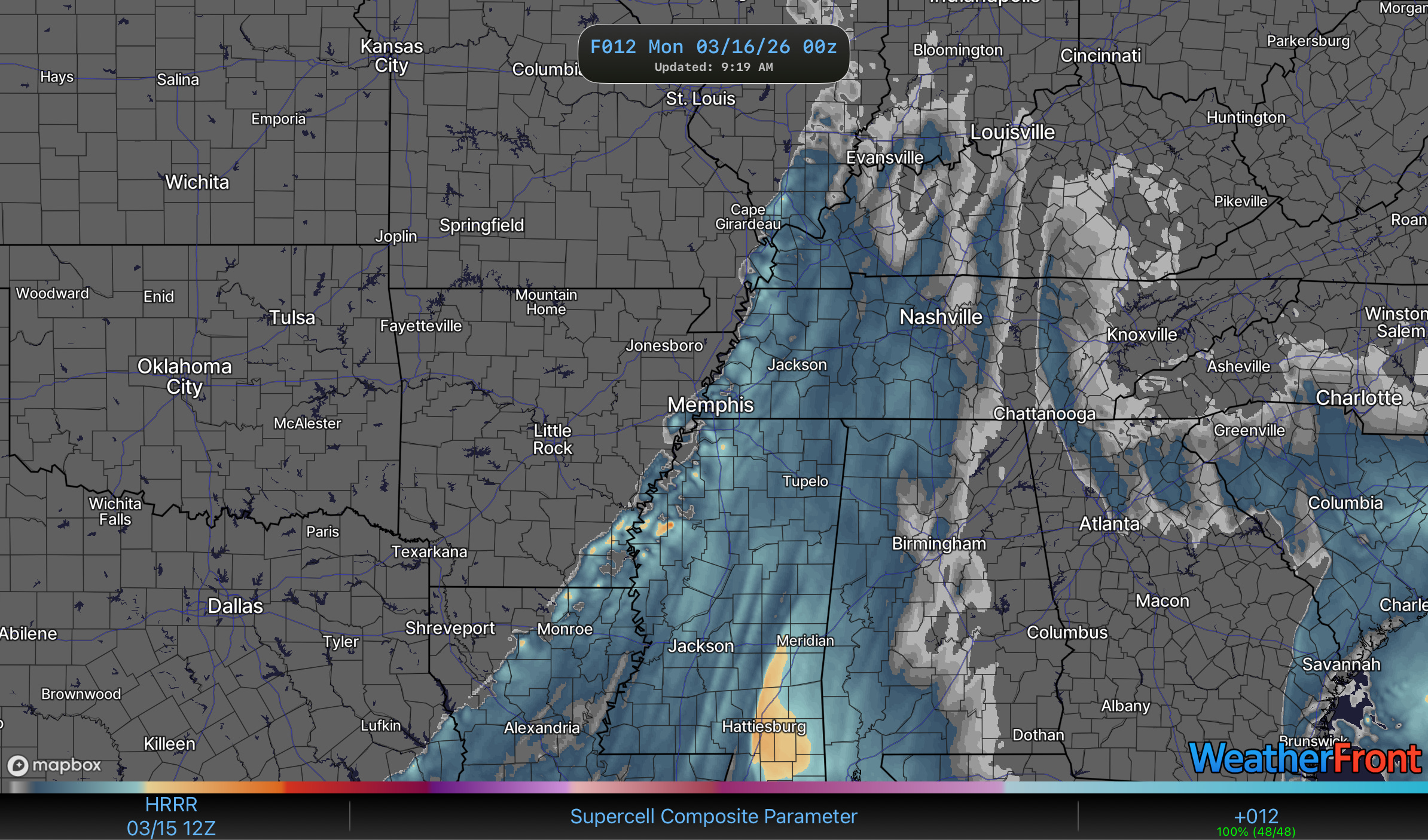
4. Overlay the Environment: Supercell Composite + Significant Tornado Parameter
Here’s where you start stacking information. Pull up the Supercell Composite (SCP) chart — same site, same model. This shows you where the overall atmospheric environment is most favorable for supercell thunderstorms. Where you see the highest values (brightest colors on the map), that’s where conditions are most primed. SCP is not perfect, but this is a basic instruction so just keep in mind it does have some practical limitations.
Now overlay that mentally with where your storms were forming in charts 2 and 3. Storms forming in the area with the highest supercell composite values? That’s your bullseye for the most significant severe weather of the day.
For tornadoes specifically, add one more layer: the Significant Tornado Parameter (STP). Find where the strongest 0–3 km vorticity tracks line up with the highest STP values. Where those two agree, that’s your best bet for tornado potential. Chasers call this “target selection” — and these four charts are genuinely how most of us start narrowing it down (even if we don’t want to admit it).
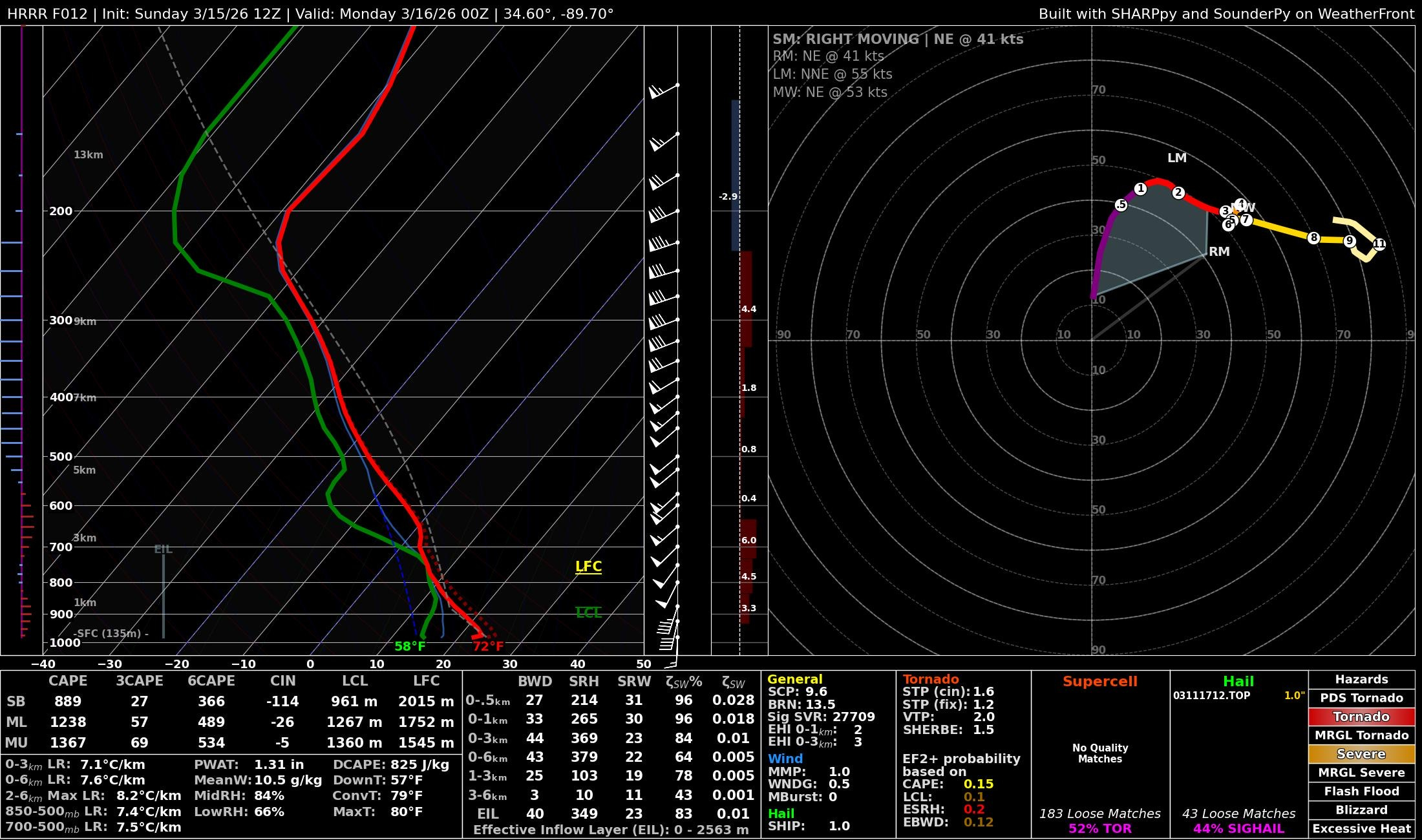
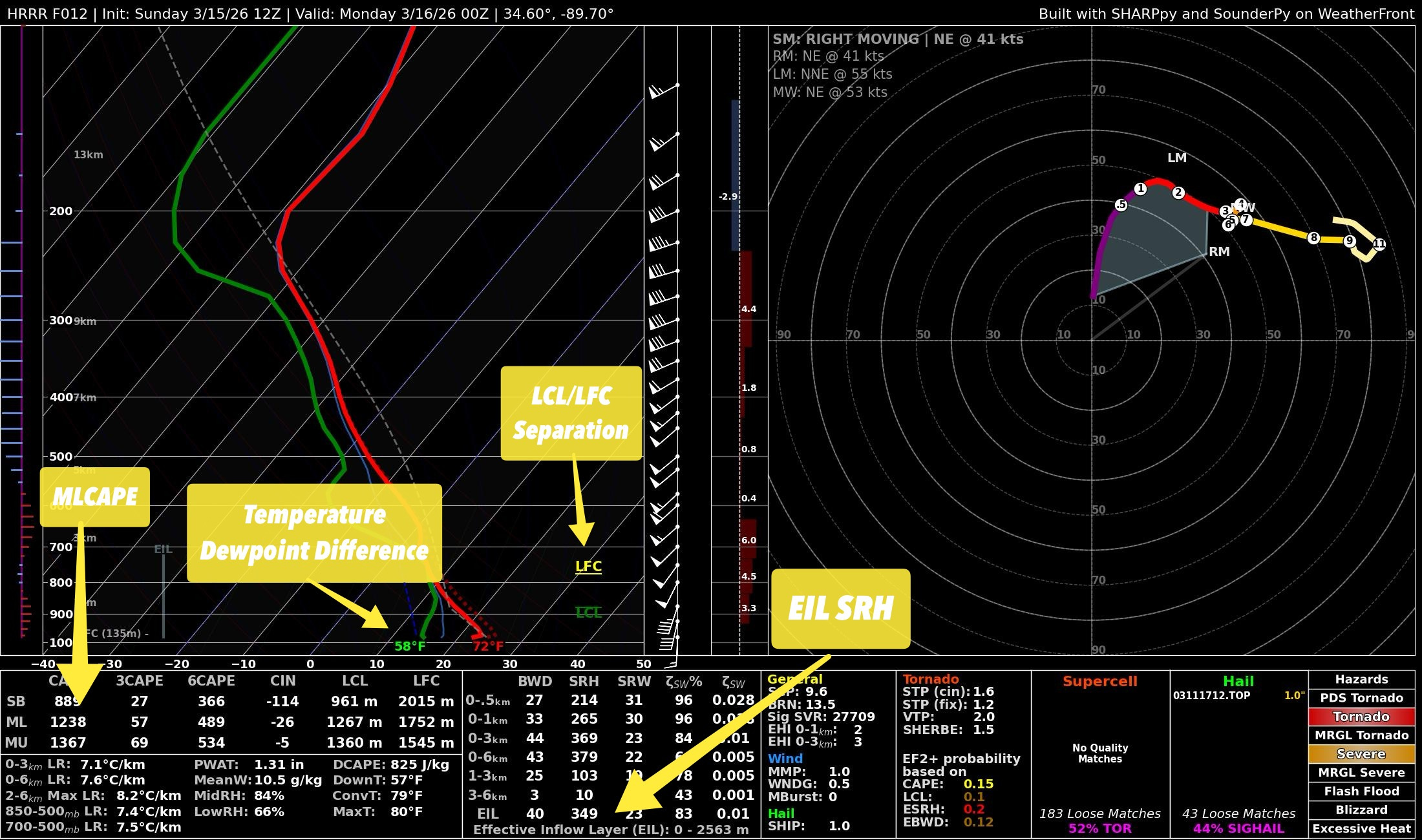
5. Confirm It With a Sounding (It’s Easier Than It Looks)
This is the one that scares people off, and it shouldn’t. Go back to that Supercell Composite map and click directly on the area you’ve been zeroing in on. It’ll pull up a sounding — a vertical profile of the atmosphere at that point.
It looks like another language. It kind of is. But you only need to check four things:
Temperature-Dewpoint Spread: Find the temperature line and the dewpoint line. Subtract the dewpoint from the temperature. If the difference is 20°F or less, cloud bases will be low enough that tornadoes are very much on the table. Between 20–30°F, you’re looking at potentially photogenic supercells with large hail and strong winds. Above 30°F, storms can still be severe, but they’ll tend to be higher-based and less likely to produce tornadoes.
LCL and LFC Separation: Find these two values (they’ll be labeled). You want them close together. When they’re tight, it means the atmosphere is uncapped — storms can fire easily and sustain themselves. When there’s a big gap, storms struggle to get going and stay going.
Effective Storm-Relative Helicity (SRH): Find this value and check it against the scale provided. Higher is better for organized, rotating storms. Tornadoes become more likely at values of over 150 m2/s2. Simple as that.
MLCAPE (Mixed-Layer Convective Available Potential Energy): This tells you how much fuel is in the atmosphere. Think of it as the storm’s energy budget. There are standard categories from “weak” through “extreme”. Ideally I like at least 1500 j/kg MLCAPE for storm chasing but if you are looking for severe weather near your home, 500 j/kg or more is notable.
Here is where you can find each of these on WeatherFront:
That’s it. You now have a target area with environmental confirmation. You know where storms are forming, which ones might rotate, and whether the atmosphere can support something significant.
Watch the full video about this technique here:
Put it all together and this is genuinely the process: SPC narrows the region, the model charts identify specific storms and rotation, the composite parameters tell you where the environment is most volatile, and the sounding confirms the details. Most chasers you see on YouTube did some version of this exact workflow before they ever left their driveway.
Is this a perfect workflow? No. Is it the full picture? Not even close — there are layers upon layers of nuance that take years to develop a feel for. But you now have a legitimate foundation to build off of. You can look at a forecast day and form your own opinion about what’s going to happen and where. Test it out, and notice patterns and trends and build upon this foundation to improve your own forecasts.
And, as always, trust the experts at the NWS and SPC when it comes to life-saving actions.
Weather is for everybody. That includes you.