

Did Someone Order Up a Dry December? 🌵
The pattern has once again flipped back to a drier La Niña pattern.

We’re through the first week of December and almost to the time of later sunsets (which always puts this storm chasers’ heart at ease) — but before we get to Spring we do have a winter season to get through. Let’s talk about it…
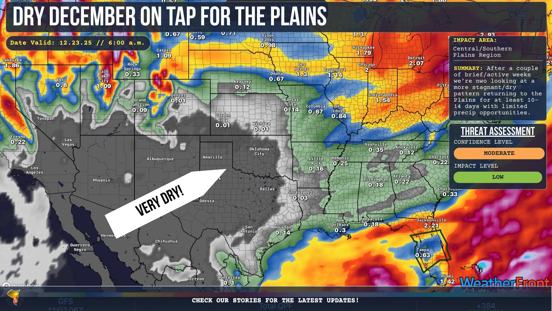
1. Dry December on Tap
Summary: Persistent ridging over the Southwest will push the jet stream up and over the Southern and Central Plains as well. This will result in a pattern that is forecast to remain pretty dry through the middle of the month.
Zooming In: This is a pattern that’s pretty typical of a La Niña winter.
Warm/Dry Southwest: Typically in a La Niña winter, a ridge sets up bringing warmer/drier conditions in the southwest with the jet stream amplifying further east. This can lead to wetter conditions in the Midwest and northeast (and in winter’s case, snowier conditions).
Plains Battleground: Often in these types of patterns, the Central/Southern Plains see a huge gradient from above average temps in the 60s and 70s to below average temps in the 20s and 30s. This will likely be the case a lot of days in the coming couple of weeks.
The Flipside: The weather pattern is rather stagnant to be sure in this type of pattern, but when it does flip to more active it oftentimes comes with near record cold temperatures and massive snowfall events for the Plains.
Temperature Check: Despite the ridge in the Southwest pushing the jet stream to an unfavorable angle, expect continued blasts of cold air to move south just as you start to feel comfortable with warmer air again. It’s a tease to be sure. We’re not expecting any actual severe weather out of this pattern.
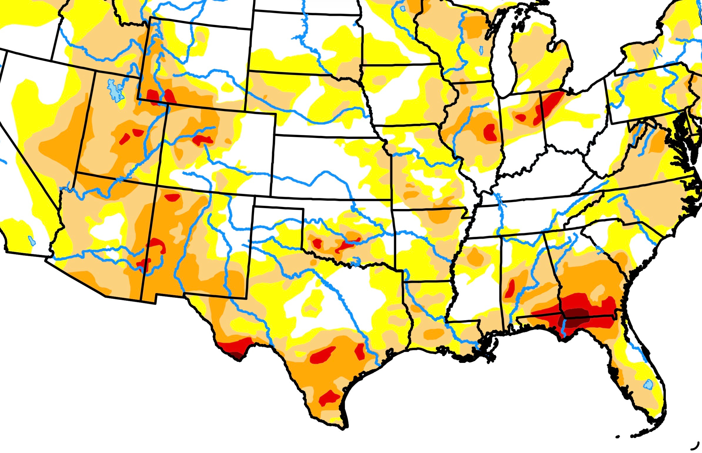
2. Drought Rising, Tornado Season Waning?
Tornado Seasons when drought conditions are strong across New Mexico and parts of Western/SW Texas, can be more violatile.
Tale of Two Extremes:
Some of our quietest tornado seasons of the last couple of decades occured in years with strong drought in this region of the country (and creeping into the Plains). This includes 2018 and 2014.
But some of our most violatile years with violent tornadoes on the Plains also had these conditions, including 2011 and 2013.
There’s a real boom or bust factor to these types of seasons.
3. The Chase Story of Arnett’s Near-Miss!
The May 18, 2025, storm chase was probably one of the most documented tornado events of 2025 with hundreds of storm chasers flocking to Western Oklahoma for what turned out to be a single, powerful supercell. This is our story of how that day unfolded, with our documentation of an EF-3 tornado near Arnett that came within yards of going through the middle of town!
They certainly didn't order up a dry December in northern South Dakota. But blizzards, heavy snow and cold up here isn't reported on much nationally - well - because it's South (and North) Dakota! We just call this 'winter.'