

Big Severe Weather Episode Next Two Days
Tornadoes likely from the Midwest into the Deep South.

The system we wrote about last weekend is now emerging, and the big weather impacts we wrote about are set to come to fruition. Today and tomorrow both promise to be very active storm and fire weather days across the country.
Let’s break it down.
Severe Weather Today
I have two areas of special interest highlighted today.
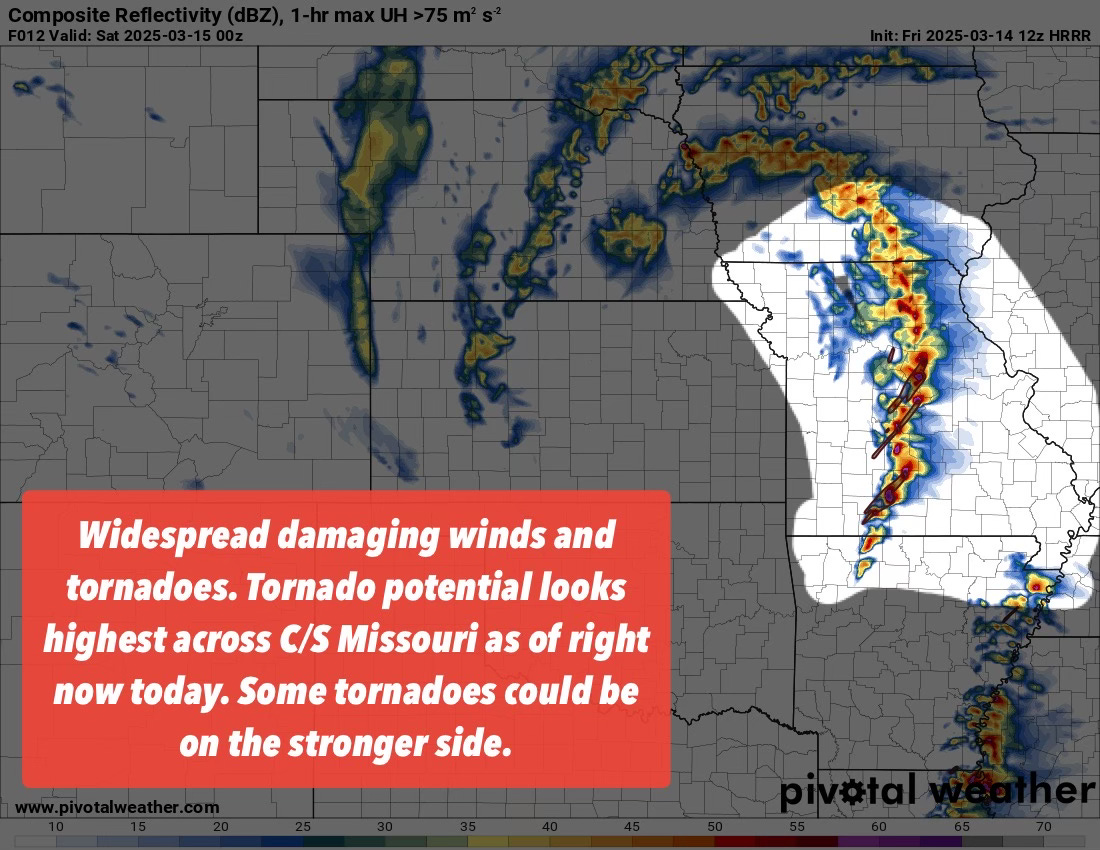
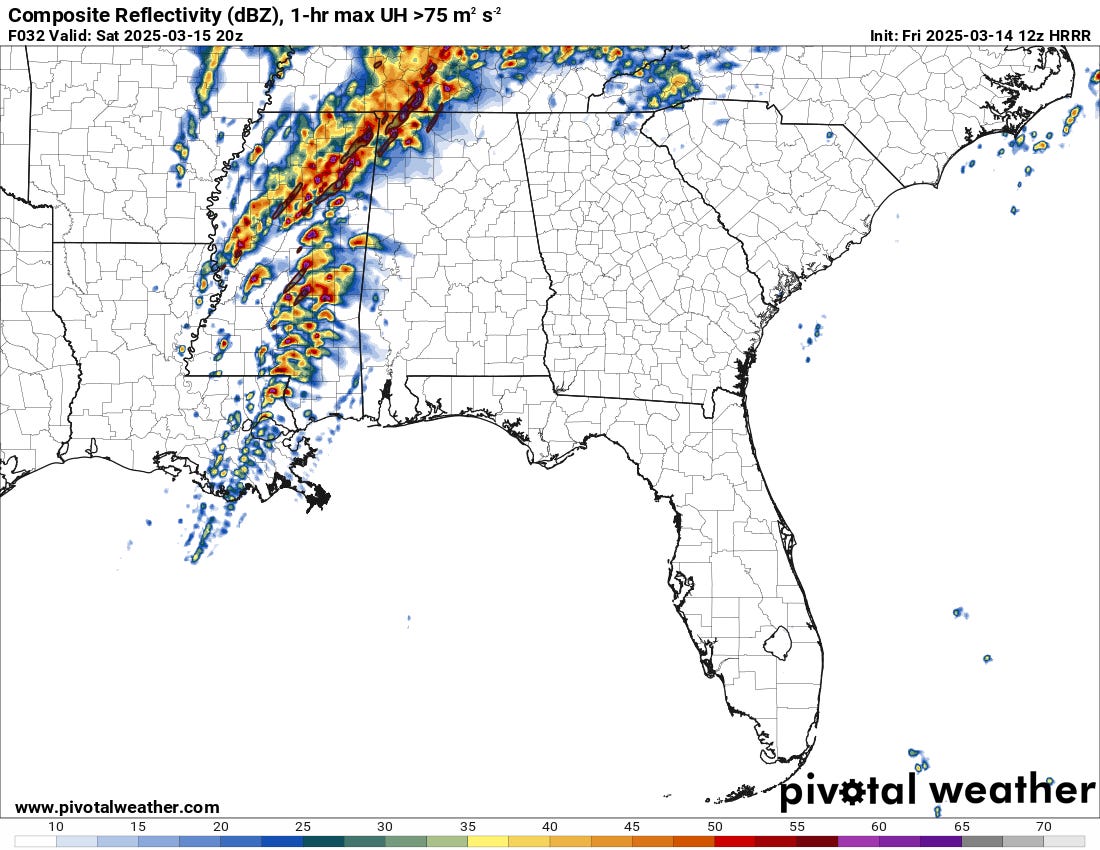
The first is across the Midwest and portions of the South, as the more difluent flow and more substantial lift overtakes a modestly unstable airmass. Models are more bullish on the updraft helicity (storm rotation) signals this morning, especially across Central and Southern Missouri. But I would not sleep on the early activity across Iowa as a tornado producer either.
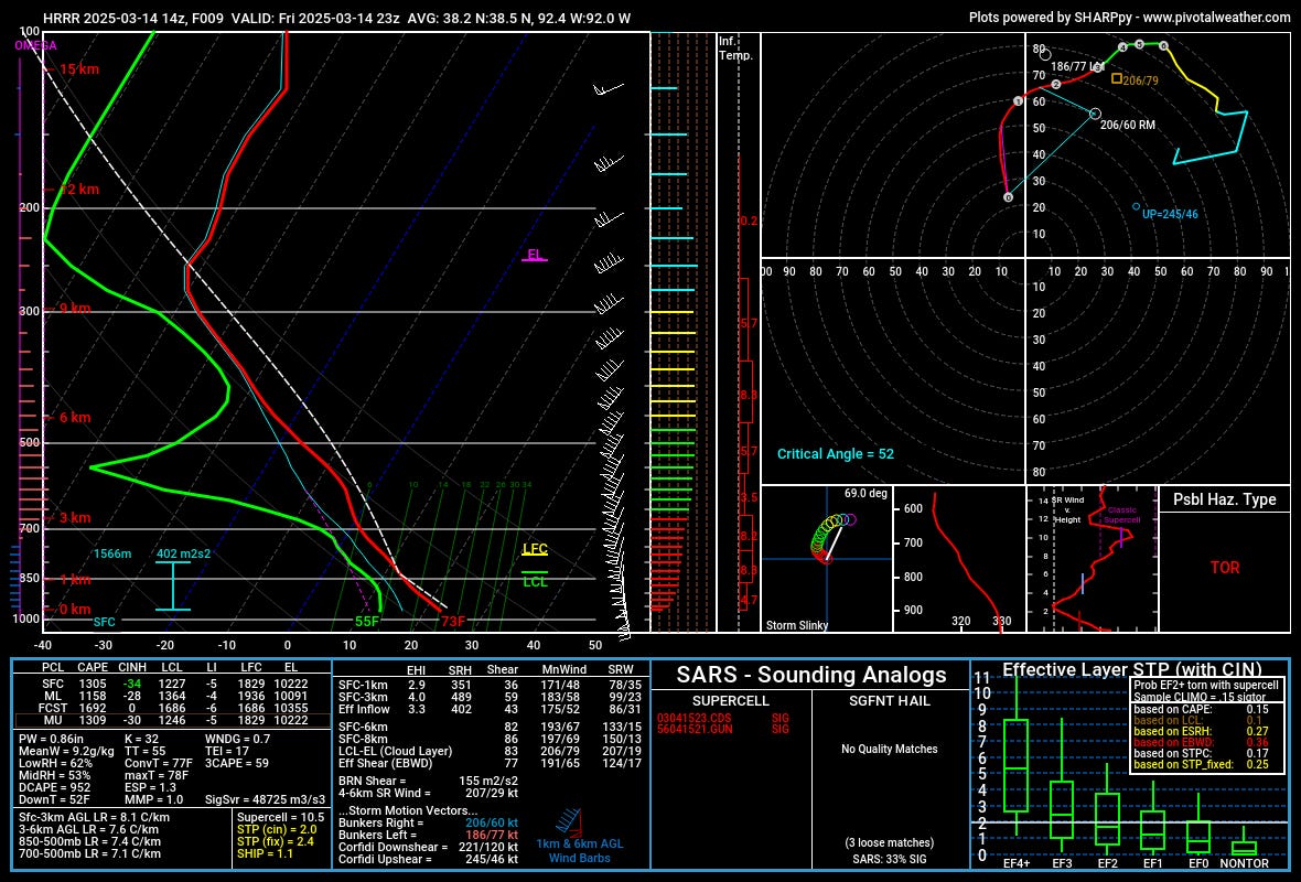
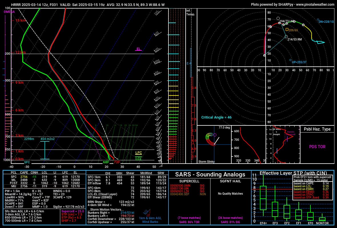
Taking a look at forecast soundings for today, you see a pretty potent and scary combination of ingredients. First, instability is on the weaker side, with ~1100 j/kg of MLCAPE across Missouri. But the wind shear is exceptionally strong, with 0-1km SRH of 351 m2s2 and 0-6km bulk shear clocking in at 82 knots!
This is extreme wind shear, and as such you can see the ‘right-mover’ storm motion is 60 knots. This equates to nearly 70 miles per hour. Pretty much unchaseable in the trees and hills of Missouri but some will certainly try.
The big thing I see that might hold today’s setup back is the pretty poor critical angle and the slight bit of inhibition due to just mid-50s dewpoints. I think both of those could limit the overall threat somewhat, which would be fortunate. But I would not bet that strongly against storms doing big things in this highly sheared environment today.
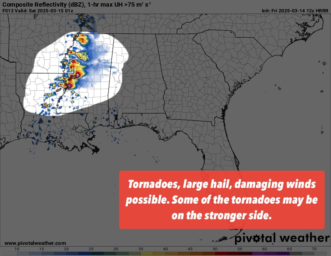
Further south, shear is weaker, but instability is higher. In some ways, the balance of ingredients and the terrain make the chasing opportunities much more favorable across eastern Louisiana and western Mississippi. Storms will form here today, with a couple likely becoming dominant supercells with very large hail and tornadoes possible.
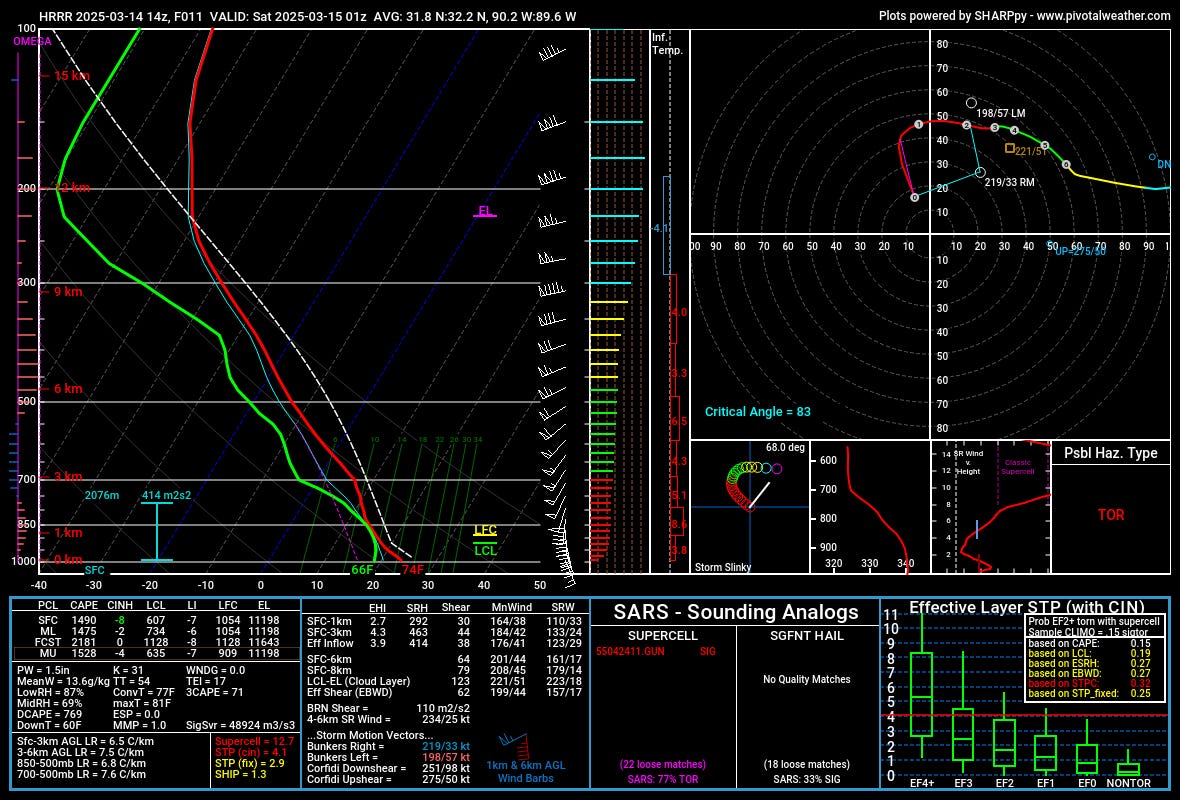
Overall, the 0-6km shear (64 knots) and 0-1km helicity (292 m2s2) are lower than further north, but the critical angle (83°) and instability (1500 j/kg MLCAPE) are both higher. The moisture is more seasonal and climatologically friendly, with dewpoints at 66°F.
From what I see, with less overall inhibition down south along with stronger low-level instability and slower storm modes, I could see this area having a strong tornado today with a dominant, right-turning supercell. While storm motions will still be faster down here (35-40 mph), they are much more manageable over much more friendly terrain for storm viewing.
Tomorrow - High Risk?
Then there is tomorrow, which is, by all accounts, a high-end environment with numbers that are on the higher side of the equation nearly across the board. The most significant limiting factor tomorrow that I see is the eventual mode/crowdedness storms take.
I have said it many times before, but storm mode is everything. Violent tornado outbreaks are much less common and likely with a linear/messy storm mode vs. a mode full of isolated supercells.
This is true no matter how good the environment looks. So, what does tomorrow look like?
As it looks right now, the storm mode looks to be on the more crowded side of things. The thing that keeps sticking into my head is that models often underdo environments like tomorrow in terms of the number of storms. For whatever reason, they don’t handle warm-sector initiation away from boundaries all that well. Even a slight increase in the number of storms tomorrow would likely lead to more destructive interactions and a limiting of the tornado threat. But a more isolated mode would lead to the opposite…
I can’t find many weaknesses from model soundings out of Mississippi and Alabama tomorrow. Instability is moderate to even strong (2500-3000 j/kg), wind shear is extreme with 0-6km shear at 70+ knots, and 0-1 helicity is clocking in at 355 m2s2.
This doesn’t even mention the 3CAPE values, which exceed 100 j/kg in many places!
There are some weaknesses in the environment, though. First, the only boundary to initiate stuff is roughly parallel with the shear vector, which will lead to messy storm modes. The critical angles are very unimpressive, too, given the fast motions (60mph+) indicated by radar.
There is almost no capping, which may lead to the warm sector becoming overwhelmed with storms as well.
Otherwise, this is a high-end environment that resembles prior big tornado outbreaks in this region in many ways. The small details will determine the ultimate outcomes tomorrow, and we’ll certainly have a couple more social media posts about that with time.
Fire Weather
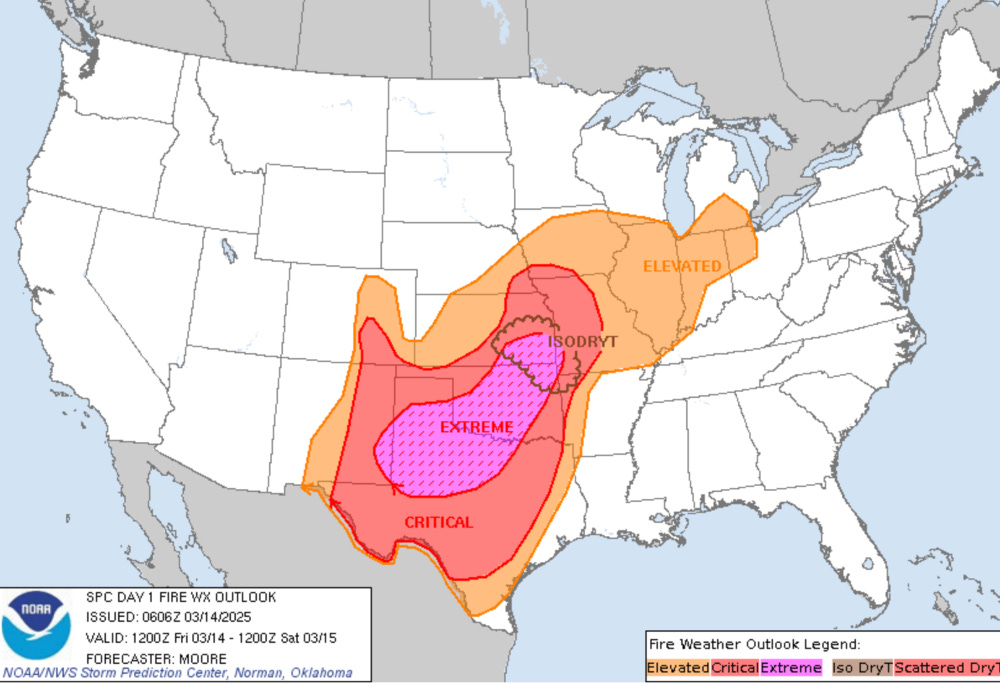
I don’t want to forget about our Plains peeps, who make up the bulk of our readership. The SPC has issued a rare, extremely critical fire risk today. A wildfire outbreak is possible, with extremely dangerous fire spread conditions likely.
It will be one of the storm will be talking about in history