This will go down as one of the weirdest seasons for me of all time when it comes to storm chasing. While I have primarily wrapped up my Spring season, I’ll eventually get back out there for the summer season, which I consider July and August.
We have actually ended up going below average on the tornado count this year as we enter late June. We’re still circling around average, and our hail reports count has trended towards average almost the entire year. We had an April – June that was almost completely full of severe weather chances and storm chase opportunities but only a couple big tornado risk days.
I suspect the cause was consistent but low-amplitude flow over the Plains, which never pushed top-quality moisture far south and never really created surface cyclones to increase the low-level winds enough. The instability was there all Spring, I chased so many days with extreme instability values, but those days often also featured very modest low-level wind shear. With the moisture and instability in place that we had, if the flow were even slightly more amplified, we probably would’ve ended up with a record year for tornadoes.
So how does it look this week?
More Flow
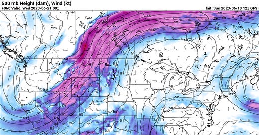
We can’t quit the modest but ever-present jet stream flow over the Central and Southern Plains. While some ridginess will build over the middle of the country, there will still be plenty of jet stream flow working overhead to create conditions favorable for severe weather.
As you can see, there is still plenty of mid-level flow over the middle of the country for severe weather this week.
The dryline will slosh around west of the caprock most of the week, with dry southwesterly flow keeping it east of the arid landscape of New Mexico. Up north in Colorado, moist upslope flow will set up by late week, leading to an uptick in severe weather chances on Thursday/Friday.
Regarding severe weather chances this week, Thursday is probably THE day to watch for the best risk of supercells and tornadoes. The SRH I’m seeing isn’t that impressive on models, but I’m sure you’d end up with at least a couple of supercells if trends were to hold.
Upper flow will finally push a cold front south next week, bringing a respite to many areas from what looks to be pretty hot temperatures. I suspect we’ll see heat advisories and excessive heat warnings for many parts of the Southern Plains next week expand.
Remember that heat is the #1 weather killer, so be sure to check on family/friends to ensure they can stay cool this week.
Looking Ahead Into the Extended
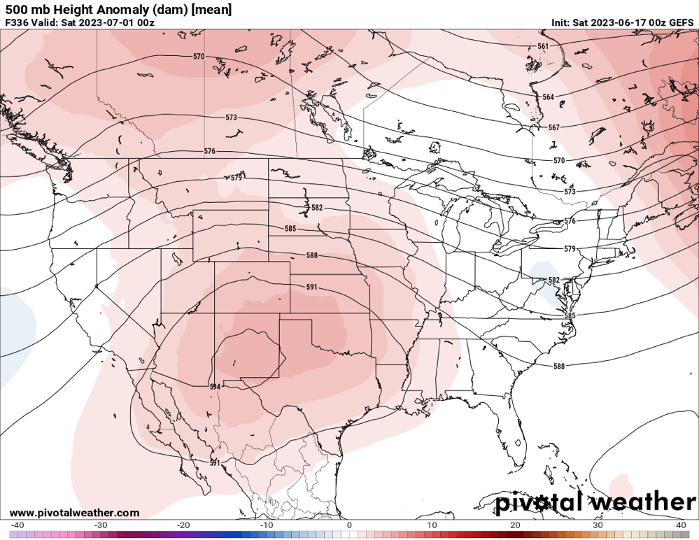
Ensembles are in pretty unified agreement that this is probably the last bit of chasing for the Southern Plains at least, as both the Euro and GEFS amplify ridging over the S/SW U.S. I’m seeing a 594 DAM ridge set up, which will mean the heat will truly be on as we move into July.
The ridge will finally flex its muscles as we move into the summer months.
As for severe weather, I think the northern U.S. will definitely see periodic shots of severe weather as flow rides up and over the ridge. But all things considered, the pattern that has dominated the U.S. for much of the past 60 days is finally on its way out.


